You are here: Home > Network List > JP - Japan Meteorological Agency Seismic Network Stations List
> Station JMZ Minamidaitojima Island > Earthquake Result Viewer
JMZ Minamidaitojima Island - Earthquake Result Viewer
| Earthquake location: |
Southern Sumatra, Indonesia |
| Earthquake latitude/longitude: |
-3.8/101.6 |
| Earthquake time(UTC): |
2017/08/13 (225) 03:08:11 GMT |
| Earthquake Depth: |
36 km |
| Earthquake Magnitude: |
6.4 Mww |
| Earthquake Catalog/Contributor: |
NEIC PDE/us |
|
| Network: |
JP Japan Meteorological Agency Seismic Network |
| Station: |
JMZ Minamidaitojima Island |
| Lat/Lon: |
25.82 N/131.22 E |
| Elevation: |
50 m |
|
| Distance: |
41.1 deg |
| Az: |
42.645 deg |
| Baz: |
228.591 deg |
| Ray Param: |
0.0739146 |
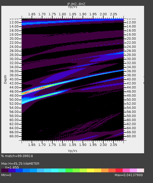
| Estimated Moho Depth: |
45.25 km |
| Estimated Crust Vp/Vs: |
1.65 |
| Assumed Crust Vp: |
4.802 km/s |
| Estimated Crust Vs: |
2.901 km/s |
| Estimated Crust Poisson's Ratio: |
0.21 |
|
| Radial Match: |
99.89916 % |
| Radial Bump: |
19 |
| Transverse Match: |
63.429577 % |
| Transverse Bump: |
400 |
| SOD ConfigId: |
13570011 |
| Insert Time: |
2019-04-28 14:17:55.103 +0000 |
| GWidth: |
2.5 |
| Max Bumps: |
400 |
| Tol: |
0.001 |
|

Signal To Noise
| Channel | StoN | STA | LTA |
| JP:JMZ: :BHZ:20170813T03:15:20.900002Z | 6.073268 | 4.76789E-6 | 7.850617E-7 |
| JP:JMZ: :BHN:20170813T03:15:20.900002Z | 1.9412361 | 1.1391916E-6 | 5.868382E-7 |
| JP:JMZ: :BHE:20170813T03:15:20.900002Z | 6.5959477 | 4.9943637E-6 | 7.571867E-7 |
| Arrivals |
| Ps | 6.4 SECOND |
| PpPs | 24 SECOND |
| PsPs/PpSs | 30 SECOND |


