You are here: Home > Network List > KO - Kandilli Observatory Digital Broadband Seismic Network Stations List
> Station SIRT Sirnak-Turkey > Earthquake Result Viewer
SIRT Sirnak-Turkey - Earthquake Result Viewer
| Earthquake location: |
Southern Sumatra, Indonesia |
| Earthquake latitude/longitude: |
-3.8/101.6 |
| Earthquake time(UTC): |
2017/08/13 (225) 03:08:11 GMT |
| Earthquake Depth: |
36 km |
| Earthquake Magnitude: |
6.4 Mww |
| Earthquake Catalog/Contributor: |
NEIC PDE/us |
|
| Network: |
KO Kandilli Observatory Digital Broadband Seismic Network |
| Station: |
SIRT Sirnak-Turkey |
| Lat/Lon: |
37.50 N/42.44 E |
| Elevation: |
1038 m |
|
| Distance: |
68.5 deg |
| Az: |
312.77 deg |
| Baz: |
112.925 deg |
| Ray Param: |
0.056224246 |
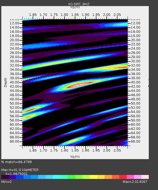
| Estimated Moho Depth: |
41.0 km |
| Estimated Crust Vp/Vs: |
1.87 |
| Assumed Crust Vp: |
6.482 km/s |
| Estimated Crust Vs: |
3.471 km/s |
| Estimated Crust Poisson's Ratio: |
0.30 |
|
| Radial Match: |
86.4799 % |
| Radial Bump: |
400 |
| Transverse Match: |
65.11285 % |
| Transverse Bump: |
400 |
| SOD ConfigId: |
13570011 |
| Insert Time: |
2019-04-28 14:18:11.486 +0000 |
| GWidth: |
2.5 |
| Max Bumps: |
400 |
| Tol: |
0.001 |
|

Signal To Noise
| Channel | StoN | STA | LTA |
| KO:SIRT: :BHZ:20170813T03:18:38.72001Z | 21.427334 | 6.5397717E-6 | 3.0520698E-7 |
| KO:SIRT: :BHN:20170813T03:18:38.72001Z | 6.560013 | 2.378032E-6 | 3.6250415E-7 |
| KO:SIRT: :BHE:20170813T03:18:38.72001Z | 9.357865 | 4.0197965E-6 | 4.2956339E-7 |
| Arrivals |
| Ps | 5.7 SECOND |
| PpPs | 17 SECOND |
| PsPs/PpSs | 23 SECOND |


