You are here: Home > Network List > TA - USArray Transportable Network (new EarthScope stations) Stations List
> Station I17K Unalakleet, AK, USA > Earthquake Result Viewer
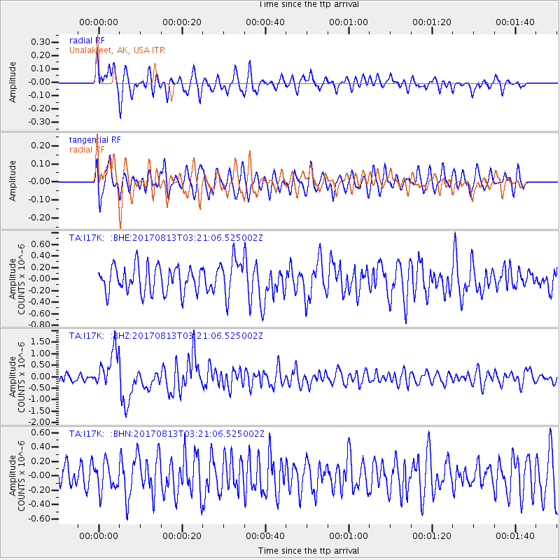
I17K Unalakleet, AK, USA - Earthquake Result Viewer
*The percent match for this event was below the threshold and hence no stack was calculated.
| Earthquake location: |
Southern Sumatra, Indonesia |
| Earthquake latitude/longitude: |
-3.8/101.6 |
| Earthquake time(UTC): |
2017/08/13 (225) 03:08:11 GMT |
| Earthquake Depth: |
36 km |
| Earthquake Magnitude: |
6.4 Mww |
| Earthquake Catalog/Contributor: |
NEIC PDE/us |
|
| Network: |
TA USArray Transportable Network (new EarthScope stations) |
| Station: |
I17K Unalakleet, AK, USA |
| Lat/Lon: |
63.89 N/160.70 W |
| Elevation: |
105 m |
|
| Distance: |
96.8 deg |
| Az: |
26.208 deg |
| Baz: |
275.251 deg |
| Ray Param: |
$rayparam |
*The percent match for this event was below the threshold and hence was not used in the summary stack. |
|
| Radial Match: |
62.96557 % |
| Radial Bump: |
400 |
| Transverse Match: |
45.370533 % |
| Transverse Bump: |
400 |
| SOD ConfigId: |
13570011 |
| Insert Time: |
2019-04-28 14:19:19.442 +0000 |
| GWidth: |
2.5 |
| Max Bumps: |
400 |
| Tol: |
0.001 |
|
Signal To Noise
| Channel | StoN | STA | LTA |
| TA:I17K: :BHZ:20170813T03:21:06.525002Z | 5.115252 | 8.372928E-7 | 1.6368554E-7 |
| TA:I17K: :BHN:20170813T03:21:06.525002Z | 1.1828439 | 1.8954961E-7 | 1.6024904E-7 |
| TA:I17K: :BHE:20170813T03:21:06.525002Z | 1.5750204 | 3.5166286E-7 | 2.2327512E-7 |
| Arrivals |
| Ps | |
| PpPs | |
| PsPs/PpSs | |


