You are here: Home > Network List > TA - USArray Transportable Network (new EarthScope stations) Stations List
> Station K15K Wolf Creek Mountain, AK, USA > Earthquake Result Viewer
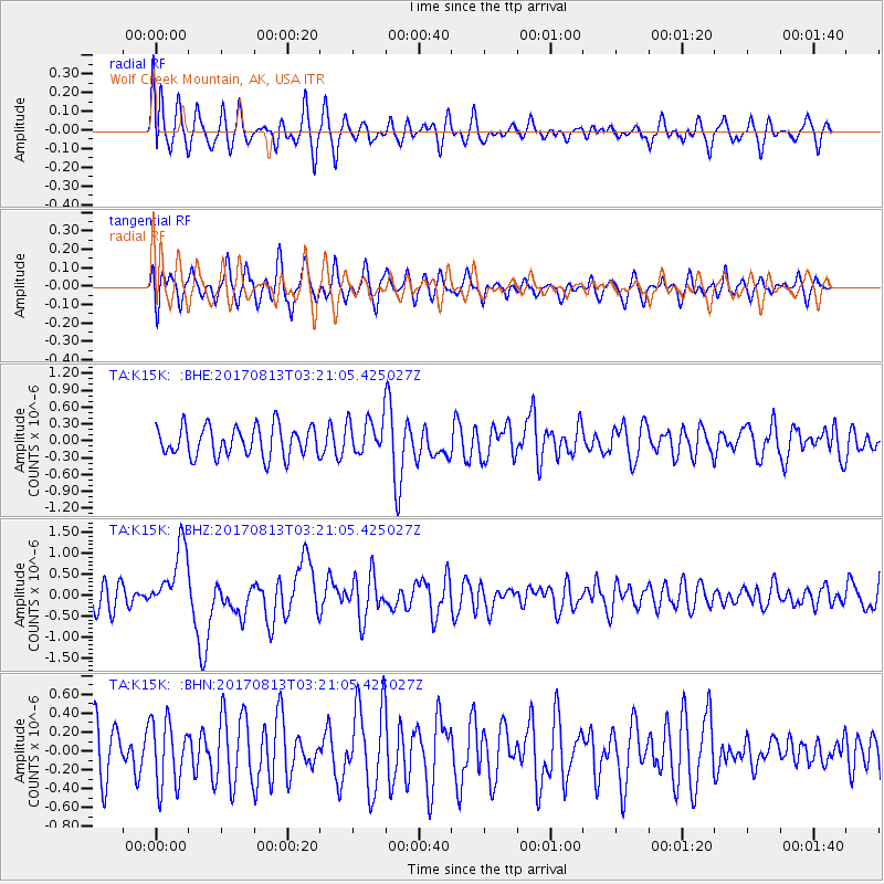
K15K Wolf Creek Mountain, AK, USA - Earthquake Result Viewer
*The percent match for this event was below the threshold and hence no stack was calculated.
| Earthquake location: |
Southern Sumatra, Indonesia |
| Earthquake latitude/longitude: |
-3.8/101.6 |
| Earthquake time(UTC): |
2017/08/13 (225) 03:08:11 GMT |
| Earthquake Depth: |
36 km |
| Earthquake Magnitude: |
6.4 Mww |
| Earthquake Catalog/Contributor: |
NEIC PDE/us |
|
| Network: |
TA USArray Transportable Network (new EarthScope stations) |
| Station: |
K15K Wolf Creek Mountain, AK, USA |
| Lat/Lon: |
62.29 N/161.53 W |
| Elevation: |
346 m |
|
| Distance: |
96.5 deg |
| Az: |
27.844 deg |
| Baz: |
274.317 deg |
| Ray Param: |
$rayparam |
*The percent match for this event was below the threshold and hence was not used in the summary stack. |
|
| Radial Match: |
62.697678 % |
| Radial Bump: |
400 |
| Transverse Match: |
58.21338 % |
| Transverse Bump: |
400 |
| SOD ConfigId: |
13570011 |
| Insert Time: |
2019-04-28 14:19:22.144 +0000 |
| GWidth: |
2.5 |
| Max Bumps: |
400 |
| Tol: |
0.001 |
|
Signal To Noise
| Channel | StoN | STA | LTA |
| TA:K15K: :BHZ:20170813T03:21:05.425027Z | 2.5923343 | 7.9149567E-7 | 3.053216E-7 |
| TA:K15K: :BHN:20170813T03:21:05.425027Z | 1.3987225 | 3.4370552E-7 | 2.4572816E-7 |
| TA:K15K: :BHE:20170813T03:21:05.425027Z | 1.4166609 | 3.7915052E-7 | 2.6763678E-7 |
| Arrivals |
| Ps | |
| PpPs | |
| PsPs/PpSs | |


