You are here: Home > Network List > CI - Caltech Regional Seismic Network Stations List
> Station DGR Domenigoni Reservoir, California, USA > Earthquake Result Viewer
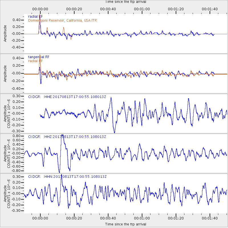
DGR Domenigoni Reservoir, California, USA - Earthquake Result Viewer
*The percent match for this event was below the threshold and hence no stack was calculated.
| Earthquake location: |
Central Peru |
| Earthquake latitude/longitude: |
-10.7/-74.6 |
| Earthquake time(UTC): |
2017/08/13 (225) 16:51:22 GMT |
| Earthquake Depth: |
21 km |
| Earthquake Magnitude: |
5.6 mb |
| Earthquake Catalog/Contributor: |
NEIC PDE/us |
|
| Network: |
CI Caltech Regional Seismic Network |
| Station: |
DGR Domenigoni Reservoir, California, USA |
| Lat/Lon: |
33.65 N/117.01 W |
| Elevation: |
609 m |
|
| Distance: |
59.8 deg |
| Az: |
319.353 deg |
| Baz: |
129.871 deg |
| Ray Param: |
$rayparam |
*The percent match for this event was below the threshold and hence was not used in the summary stack. |
|
| Radial Match: |
79.150604 % |
| Radial Bump: |
400 |
| Transverse Match: |
70.36657 % |
| Transverse Bump: |
400 |
| SOD ConfigId: |
13570011 |
| Insert Time: |
2019-04-28 14:21:50.918 +0000 |
| GWidth: |
2.5 |
| Max Bumps: |
400 |
| Tol: |
0.001 |
|
Signal To Noise
| Channel | StoN | STA | LTA |
| CI:DGR: :HHZ:20170813T17:00:55.108013Z | 3.0297565 | 2.0369231E-7 | 6.723058E-8 |
| CI:DGR: :HHN:20170813T17:00:55.108013Z | 1.8306693 | 8.230596E-8 | 4.495949E-8 |
| CI:DGR: :HHE:20170813T17:00:55.108013Z | 2.1375864 | 7.38194E-8 | 3.4533997E-8 |
| Arrivals |
| Ps | |
| PpPs | |
| PsPs/PpSs | |


