You are here: Home > Network List > WI - West Indies IPGP Network Stations List
> Station DHS Morne Mazeau - Deshaies, Guadeloupe > Earthquake Result Viewer
DHS Morne Mazeau - Deshaies, Guadeloupe - Earthquake Result Viewer
| Earthquake location: |
Strait Of Gibraltar |
| Earthquake latitude/longitude: |
35.7/-3.6 |
| Earthquake time(UTC): |
2016/01/25 (025) 04:22:02 GMT |
| Earthquake Depth: |
10 km |
| Earthquake Magnitude: |
6.1 MWP |
| Earthquake Catalog/Contributor: |
NEIC PDE/NEIC COMCAT |
|
| Network: |
WI West Indies IPGP Network |
| Station: |
DHS Morne Mazeau - Deshaies, Guadeloupe |
| Lat/Lon: |
16.27 N/61.77 W |
| Elevation: |
618 m |
|
| Distance: |
55.0 deg |
| Az: |
265.234 deg |
| Baz: |
57.576 deg |
| Ray Param: |
0.06510612 |
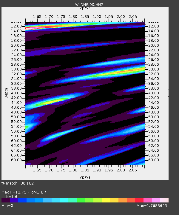
| Estimated Moho Depth: |
12.75 km |
| Estimated Crust Vp/Vs: |
1.60 |
| Assumed Crust Vp: |
6.048 km/s |
| Estimated Crust Vs: |
3.78 km/s |
| Estimated Crust Poisson's Ratio: |
0.18 |
|
| Radial Match: |
80.182 % |
| Radial Bump: |
400 |
| Transverse Match: |
57.963688 % |
| Transverse Bump: |
400 |
| SOD ConfigId: |
1399611 |
| Insert Time: |
2016-02-08 05:00:42.920 +0000 |
| GWidth: |
2.5 |
| Max Bumps: |
400 |
| Tol: |
0.001 |
|

Signal To Noise
| Channel | StoN | STA | LTA |
| WI:DHS:00:HHZ:20160125T04:31:03.090005Z | 2.849254 | 1.0140169E-6 | 3.5588857E-7 |
| WI:DHS:00:HHN:20160125T04:31:03.090005Z | 1.782976 | 7.115297E-7 | 3.9906857E-7 |
| WI:DHS:00:HHE:20160125T04:31:03.090005Z | 1.1406891 | 6.5302237E-7 | 5.724806E-7 |
| Arrivals |
| Ps | 1.3 SECOND |
| PpPs | 5.2 SECOND |
| PsPs/PpSs | 6.5 SECOND |


