You are here: Home > Network List > N4 - Central and EAstern US Network Stations List
> Station 250A Grady, AL, USA > Earthquake Result Viewer
250A Grady, AL, USA - Earthquake Result Viewer
| Earthquake location: |
Central Peru |
| Earthquake latitude/longitude: |
-10.7/-74.6 |
| Earthquake time(UTC): |
2017/08/13 (225) 16:51:22 GMT |
| Earthquake Depth: |
21 km |
| Earthquake Magnitude: |
5.6 mb |
| Earthquake Catalog/Contributor: |
NEIC PDE/us |
|
| Network: |
N4 Central and EAstern US Network |
| Station: |
250A Grady, AL, USA |
| Lat/Lon: |
31.98 N/86.27 W |
| Elevation: |
152 m |
|
| Distance: |
43.9 deg |
| Az: |
345.606 deg |
| Baz: |
163.293 deg |
| Ray Param: |
0.072224155 |
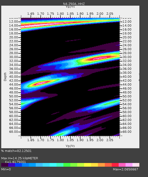
| Estimated Moho Depth: |
14.25 km |
| Estimated Crust Vp/Vs: |
1.62 |
| Assumed Crust Vp: |
6.187 km/s |
| Estimated Crust Vs: |
3.825 km/s |
| Estimated Crust Poisson's Ratio: |
0.19 |
|
| Radial Match: |
82.12501 % |
| Radial Bump: |
348 |
| Transverse Match: |
62.011196 % |
| Transverse Bump: |
400 |
| SOD ConfigId: |
13570011 |
| Insert Time: |
2019-04-28 14:23:57.659 +0000 |
| GWidth: |
2.5 |
| Max Bumps: |
400 |
| Tol: |
0.001 |
|

Signal To Noise
| Channel | StoN | STA | LTA |
| N4:250A: :HHZ:20170813T16:58:56.859996Z | 3.5238628 | 2.3358041E-7 | 6.628533E-8 |
| N4:250A: :HHN:20170813T16:58:56.859996Z | 1.2864718 | 1.3968774E-7 | 1.0858204E-7 |
| N4:250A: :HHE:20170813T16:58:56.859996Z | 2.6973758 | 2.9546058E-7 | 1.0953631E-7 |
| Arrivals |
| Ps | 1.5 SECOND |
| PpPs | 5.6 SECOND |
| PsPs/PpSs | 7.2 SECOND |


