You are here: Home > Network List > WY - Yellowstone Wyoming Seismic Network Stations List
> Station YHR Hawk's Rest, WY, USA > Earthquake Result Viewer
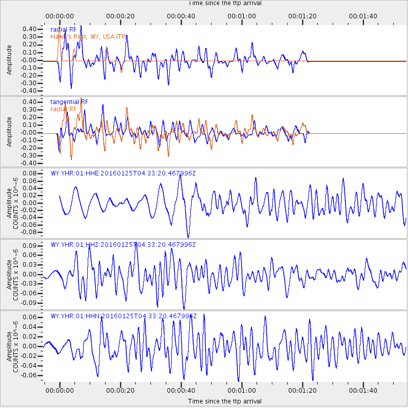
YHR Hawk's Rest, WY, USA - Earthquake Result Viewer
*The percent match for this event was below the threshold and hence no stack was calculated.
| Earthquake location: |
Strait Of Gibraltar |
| Earthquake latitude/longitude: |
35.7/-3.6 |
| Earthquake time(UTC): |
2016/01/25 (025) 04:22:02 GMT |
| Earthquake Depth: |
10 km |
| Earthquake Magnitude: |
6.1 MWP |
| Earthquake Catalog/Contributor: |
NEIC PDE/NEIC COMCAT |
|
| Network: |
WY Yellowstone Wyoming Seismic Network |
| Station: |
YHR Hawk's Rest, WY, USA |
| Lat/Lon: |
44.11 N/110.08 W |
| Elevation: |
2976 m |
|
| Distance: |
76.3 deg |
| Az: |
314.68 deg |
| Baz: |
53.415 deg |
| Ray Param: |
$rayparam |
*The percent match for this event was below the threshold and hence was not used in the summary stack. |
|
| Radial Match: |
75.26307 % |
| Radial Bump: |
400 |
| Transverse Match: |
76.89099 % |
| Transverse Bump: |
384 |
| SOD ConfigId: |
1399611 |
| Insert Time: |
2016-02-08 05:01:10.757 +0000 |
| GWidth: |
2.5 |
| Max Bumps: |
400 |
| Tol: |
0.001 |
|
Signal To Noise
| Channel | StoN | STA | LTA |
| WY:YHR:01:HHZ:20160125T04:33:20.467996Z | 1.8296865 | 1.8012392E-8 | 9.844523E-9 |
| WY:YHR:01:HHN:20160125T04:33:20.467996Z | 0.69684243 | 1.2049836E-8 | 1.7292052E-8 |
| WY:YHR:01:HHE:20160125T04:33:20.467996Z | 1.6433004 | 3.154492E-8 | 1.9196078E-8 |
| Arrivals |
| Ps | |
| PpPs | |
| PsPs/PpSs | |


