You are here: Home > Network List > N4 - Central and EAstern US Network Stations List
> Station W45B Hickory Valley, TN, USA > Earthquake Result Viewer
W45B Hickory Valley, TN, USA - Earthquake Result Viewer
| Earthquake location: |
Central Peru |
| Earthquake latitude/longitude: |
-10.7/-74.6 |
| Earthquake time(UTC): |
2017/08/13 (225) 16:51:22 GMT |
| Earthquake Depth: |
21 km |
| Earthquake Magnitude: |
5.6 mb |
| Earthquake Catalog/Contributor: |
NEIC PDE/us |
|
| Network: |
N4 Central and EAstern US Network |
| Station: |
W45B Hickory Valley, TN, USA |
| Lat/Lon: |
35.16 N/89.19 W |
| Elevation: |
182 m |
|
| Distance: |
47.7 deg |
| Az: |
343.754 deg |
| Baz: |
160.393 deg |
| Ray Param: |
0.06981547 |
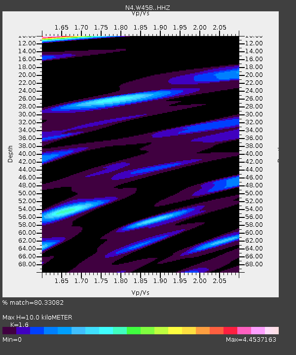
| Estimated Moho Depth: |
10.0 km |
| Estimated Crust Vp/Vs: |
1.60 |
| Assumed Crust Vp: |
6.38 km/s |
| Estimated Crust Vs: |
3.988 km/s |
| Estimated Crust Poisson's Ratio: |
0.18 |
|
| Radial Match: |
80.33082 % |
| Radial Bump: |
400 |
| Transverse Match: |
63.825886 % |
| Transverse Bump: |
400 |
| SOD ConfigId: |
13570011 |
| Insert Time: |
2019-04-28 14:24:51.844 +0000 |
| GWidth: |
2.5 |
| Max Bumps: |
400 |
| Tol: |
0.001 |
|

Signal To Noise
| Channel | StoN | STA | LTA |
| N4:W45B: :HHZ:20170813T16:59:26.590007Z | 3.4300828 | 2.9204207E-7 | 8.51414E-8 |
| N4:W45B: :HHN:20170813T16:59:26.590007Z | 0.9033789 | 2.9047973E-7 | 3.2154807E-7 |
| N4:W45B: :HHE:20170813T16:59:26.590007Z | 1.043268 | 1.5101347E-7 | 1.4475042E-7 |
| Arrivals |
| Ps | 1.0 SECOND |
| PpPs | 3.8 SECOND |
| PsPs/PpSs | 4.8 SECOND |


