You are here: Home > Network List > TA - USArray Transportable Network (new EarthScope stations) Stations List
> Station K07A Rock Creek Ranch, Frenchglen, OR, USA > Earthquake Result Viewer
K07A Rock Creek Ranch, Frenchglen, OR, USA - Earthquake Result Viewer
| Earthquake location: |
Southeast Of Loyalty Islands |
| Earthquake latitude/longitude: |
-21.1/169.3 |
| Earthquake time(UTC): |
2007/09/27 (270) 19:57:44 GMT |
| Earthquake Depth: |
9.0 km |
| Earthquake Magnitude: |
6.2 MB, 6.3 MS, 6.1 MW, 6.1 MW |
| Earthquake Catalog/Contributor: |
WHDF/NEIC |
|
| Network: |
TA USArray Transportable Network (new EarthScope stations) |
| Station: |
K07A Rock Creek Ranch, Frenchglen, OR, USA |
| Lat/Lon: |
42.69 N/119.25 W |
| Elevation: |
1407 m |
|
| Distance: |
91.3 deg |
| Az: |
44.367 deg |
| Baz: |
242.322 deg |
| Ray Param: |
0.04161062 |
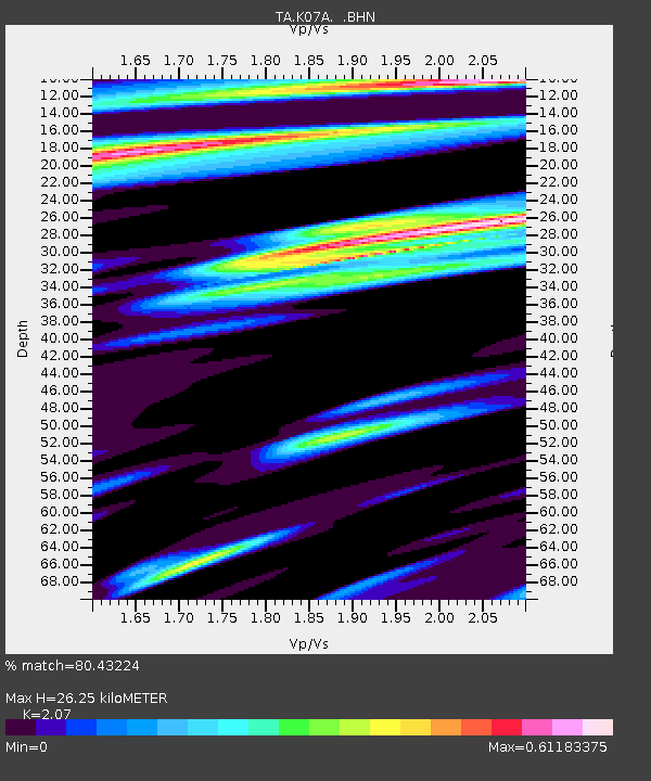
| Estimated Moho Depth: |
26.25 km |
| Estimated Crust Vp/Vs: |
2.07 |
| Assumed Crust Vp: |
6.279 km/s |
| Estimated Crust Vs: |
3.033 km/s |
| Estimated Crust Poisson's Ratio: |
0.35 |
|
| Radial Match: |
80.43224 % |
| Radial Bump: |
400 |
| Transverse Match: |
79.27215 % |
| Transverse Bump: |
380 |
| SOD ConfigId: |
2564 |
| Insert Time: |
2010-03-06 02:50:57.863 +0000 |
| GWidth: |
2.5 |
| Max Bumps: |
400 |
| Tol: |
0.001 |
|
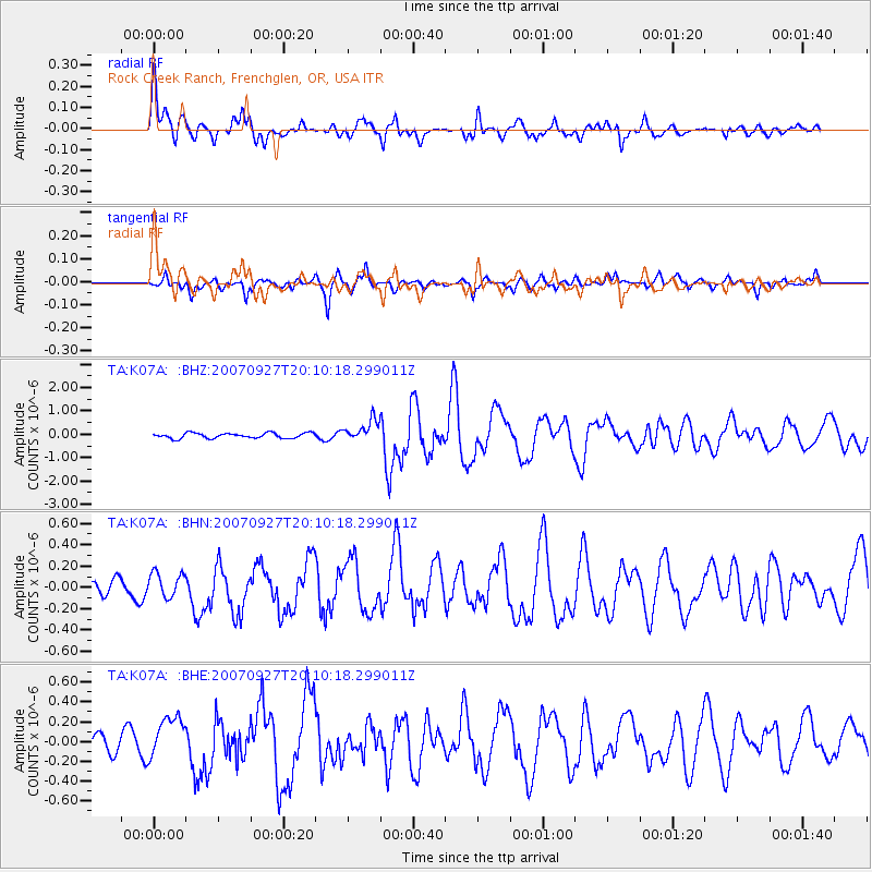
Signal To Noise
| Channel | StoN | STA | LTA |
| TA:K07A: :BHN:20070927T20:10:18.299011Z | 1.4311618 | 1.1286417E-7 | 7.886192E-8 |
| TA:K07A: :BHE:20070927T20:10:18.299011Z | 1.7811035 | 2.0915088E-7 | 1.174277E-7 |
| TA:K07A: :BHZ:20070927T20:10:18.299011Z | 3.9260828 | 4.447632E-7 | 1.1328421E-7 |
| Arrivals |
| Ps | 4.5 SECOND |
| PpPs | 13 SECOND |
| PsPs/PpSs | 17 SECOND |


