You are here: Home > Network List > TA - USArray Transportable Network (new EarthScope stations) Stations List
> Station ABTX Abilene, Hawley, TX, USA > Earthquake Result Viewer
ABTX Abilene, Hawley, TX, USA - Earthquake Result Viewer

| Earthquake location: |
Central Peru |
| Earthquake latitude/longitude: |
-10.7/-74.6 |
| Earthquake time(UTC): |
2017/08/13 (225) 16:51:22 GMT |
| Earthquake Depth: |
21 km |
| Earthquake Magnitude: |
5.6 mb |
| Earthquake Catalog/Contributor: |
NEIC PDE/us |
|
| Network: |
TA USArray Transportable Network (new EarthScope stations) |
| Station: |
ABTX Abilene, Hawley, TX, USA |
| Lat/Lon: |
32.62 N/99.64 W |
| Elevation: |
502 m |
|
| Distance: |
49.3 deg |
| Az: |
331.85 deg |
| Baz: |
146.669 deg |
| Ray Param: |
0.06876313 |
| Estimated Moho Depth: |
42.75 km |
| Estimated Crust Vp/Vs: |
1.72 |
| Assumed Crust Vp: |
6.426 km/s |
| Estimated Crust Vs: |
3.736 km/s |
| Estimated Crust Poisson's Ratio: |
0.24 |
|
| Radial Match: |
88.27107 % |
| Radial Bump: |
333 |
| Transverse Match: |
70.382935 % |
| Transverse Bump: |
381 |
| SOD ConfigId: |
13570011 |
| Insert Time: |
2019-04-28 14:26:47.777 +0000 |
| GWidth: |
2.5 |
| Max Bumps: |
400 |
| Tol: |
0.001 |
|
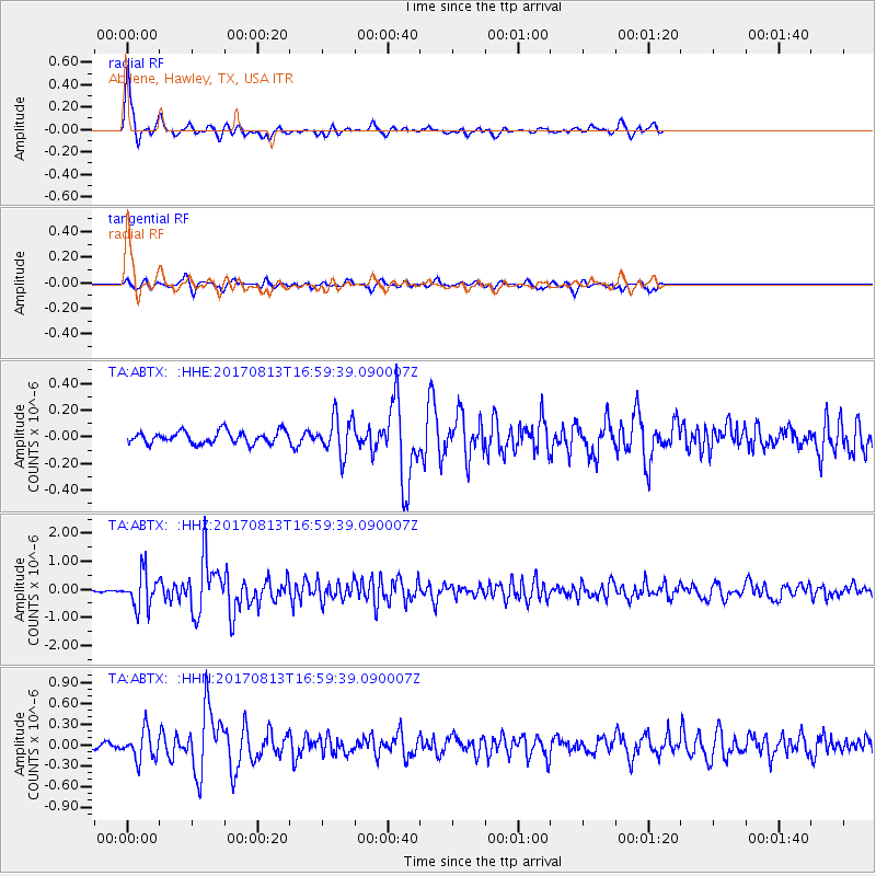
Signal To Noise
| Channel | StoN | STA | LTA |
| TA:ABTX: :HHZ:20170813T16:59:39.090007Z | 9.595567 | 6.0886003E-7 | 6.345223E-8 |
| TA:ABTX: :HHN:20170813T16:59:39.090007Z | 4.5768595 | 2.0692474E-7 | 4.5211074E-8 |
| TA:ABTX: :HHE:20170813T16:59:39.090007Z | 3.0577428 | 1.389996E-7 | 4.5458233E-8 |
| Arrivals |
| Ps | 5.1 SECOND |
| PpPs | 17 SECOND |
| PsPs/PpSs | 22 SECOND |


