You are here: Home > Network List > TA - USArray Transportable Network (new EarthScope stations) Stations List
> Station BGNE Belgrade, NE, USA > Earthquake Result Viewer
BGNE Belgrade, NE, USA - Earthquake Result Viewer
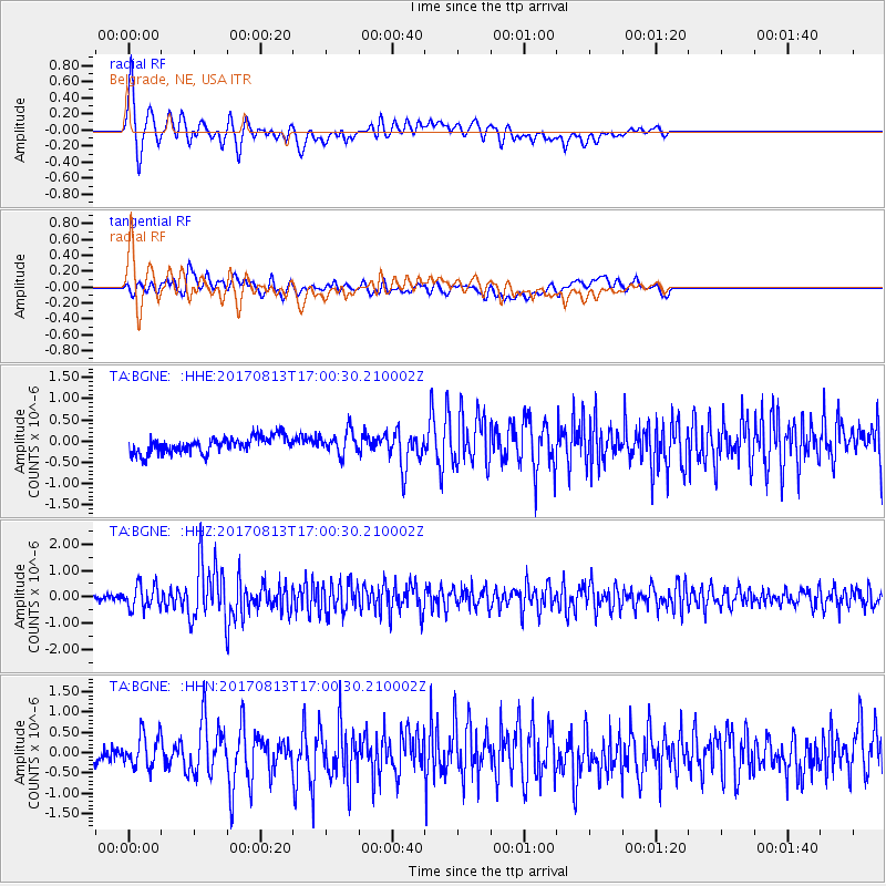
| Earthquake location: |
Central Peru |
| Earthquake latitude/longitude: |
-10.7/-74.6 |
| Earthquake time(UTC): |
2017/08/13 (225) 16:51:22 GMT |
| Earthquake Depth: |
21 km |
| Earthquake Magnitude: |
5.6 mb |
| Earthquake Catalog/Contributor: |
NEIC PDE/us |
|
| Network: |
TA USArray Transportable Network (new EarthScope stations) |
| Station: |
BGNE Belgrade, NE, USA |
| Lat/Lon: |
41.41 N/98.15 W |
| Elevation: |
573 m |
|
| Distance: |
56.2 deg |
| Az: |
338.774 deg |
| Baz: |
151.768 deg |
| Ray Param: |
0.064253725 |
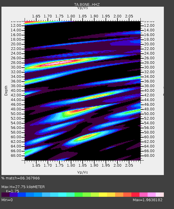
| Estimated Moho Depth: |
27.75 km |
| Estimated Crust Vp/Vs: |
1.75 |
| Assumed Crust Vp: |
6.53 km/s |
| Estimated Crust Vs: |
3.732 km/s |
| Estimated Crust Poisson's Ratio: |
0.26 |
|
| Radial Match: |
86.367966 % |
| Radial Bump: |
400 |
| Transverse Match: |
67.03023 % |
| Transverse Bump: |
400 |
| SOD ConfigId: |
13570011 |
| Insert Time: |
2019-04-28 14:26:49.410 +0000 |
| GWidth: |
2.5 |
| Max Bumps: |
400 |
| Tol: |
0.001 |
|
Signal To Noise
| Channel | StoN | STA | LTA |
| TA:BGNE: :HHZ:20170813T17:00:30.210002Z | 4.9944253 | 4.5236857E-7 | 9.0574694E-8 |
| TA:BGNE: :HHN:20170813T17:00:30.210002Z | 2.372384 | 3.9892353E-7 | 1.6815301E-7 |
| TA:BGNE: :HHE:20170813T17:00:30.210002Z | 1.3938167 | 2.6324565E-7 | 1.8886676E-7 |
| Arrivals |
| Ps | 3.4 SECOND |
| PpPs | 11 SECOND |
| PsPs/PpSs | 14 SECOND |


