You are here: Home > Network List > TA - USArray Transportable Network (new EarthScope stations) Stations List
> Station I30M Mount Dempster, Yukon, CAN > Earthquake Result Viewer
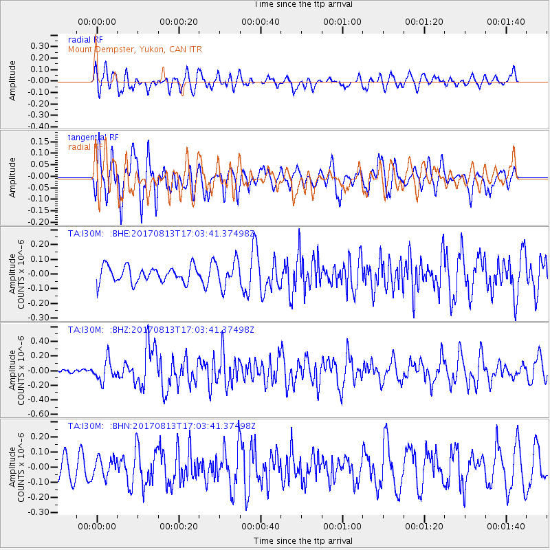
I30M Mount Dempster, Yukon, CAN - Earthquake Result Viewer
*The percent match for this event was below the threshold and hence no stack was calculated.
| Earthquake location: |
Central Peru |
| Earthquake latitude/longitude: |
-10.7/-74.6 |
| Earthquake time(UTC): |
2017/08/13 (225) 16:51:22 GMT |
| Earthquake Depth: |
21 km |
| Earthquake Magnitude: |
5.6 mb |
| Earthquake Catalog/Contributor: |
NEIC PDE/us |
|
| Network: |
TA USArray Transportable Network (new EarthScope stations) |
| Station: |
I30M Mount Dempster, Yukon, CAN |
| Lat/Lon: |
65.22 N/136.38 W |
| Elevation: |
1399 m |
|
| Distance: |
88.4 deg |
| Az: |
338.187 deg |
| Baz: |
119.935 deg |
| Ray Param: |
$rayparam |
*The percent match for this event was below the threshold and hence was not used in the summary stack. |
|
| Radial Match: |
46.23067 % |
| Radial Bump: |
400 |
| Transverse Match: |
58.226944 % |
| Transverse Bump: |
400 |
| SOD ConfigId: |
13570011 |
| Insert Time: |
2019-04-28 14:27:00.451 +0000 |
| GWidth: |
2.5 |
| Max Bumps: |
400 |
| Tol: |
0.001 |
|
Signal To Noise
| Channel | StoN | STA | LTA |
| TA:I30M: :BHZ:20170813T17:03:41.37498Z | 2.2046905 | 1.4536978E-7 | 6.59366E-8 |
| TA:I30M: :BHN:20170813T17:03:41.37498Z | 0.73312926 | 6.050473E-8 | 8.2529425E-8 |
| TA:I30M: :BHE:20170813T17:03:41.37498Z | 1.6501681 | 8.559358E-8 | 5.1869613E-8 |
| Arrivals |
| Ps | |
| PpPs | |
| PsPs/PpSs | |


