You are here: Home > Network List > TA - USArray Transportable Network (new EarthScope stations) Stations List
> Station K07A Rock Creek Ranch, Frenchglen, OR, USA > Earthquake Result Viewer
K07A Rock Creek Ranch, Frenchglen, OR, USA - Earthquake Result Viewer
| Earthquake location: |
Jujuy Province, Argentina |
| Earthquake latitude/longitude: |
-22.2/-65.8 |
| Earthquake time(UTC): |
2007/07/21 (202) 15:34:52 GMT |
| Earthquake Depth: |
290 km |
| Earthquake Magnitude: |
5.8 MB, 6.4 MW, 6.3 MW |
| Earthquake Catalog/Contributor: |
WHDF/NEIC |
|
| Network: |
TA USArray Transportable Network (new EarthScope stations) |
| Station: |
K07A Rock Creek Ranch, Frenchglen, OR, USA |
| Lat/Lon: |
42.69 N/119.25 W |
| Elevation: |
1407 m |
|
| Distance: |
81.2 deg |
| Az: |
323.162 deg |
| Baz: |
131.072 deg |
| Ray Param: |
0.047018014 |
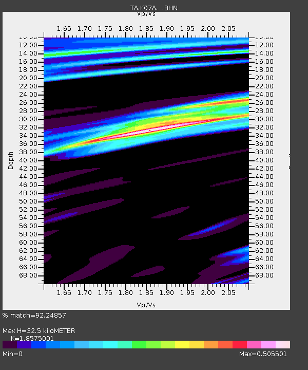
| Estimated Moho Depth: |
32.5 km |
| Estimated Crust Vp/Vs: |
1.86 |
| Assumed Crust Vp: |
6.279 km/s |
| Estimated Crust Vs: |
3.38 km/s |
| Estimated Crust Poisson's Ratio: |
0.30 |
|
| Radial Match: |
92.24857 % |
| Radial Bump: |
310 |
| Transverse Match: |
70.739815 % |
| Transverse Bump: |
400 |
| SOD ConfigId: |
2564 |
| Insert Time: |
2010-03-06 02:51:16.321 +0000 |
| GWidth: |
2.5 |
| Max Bumps: |
400 |
| Tol: |
0.001 |
|
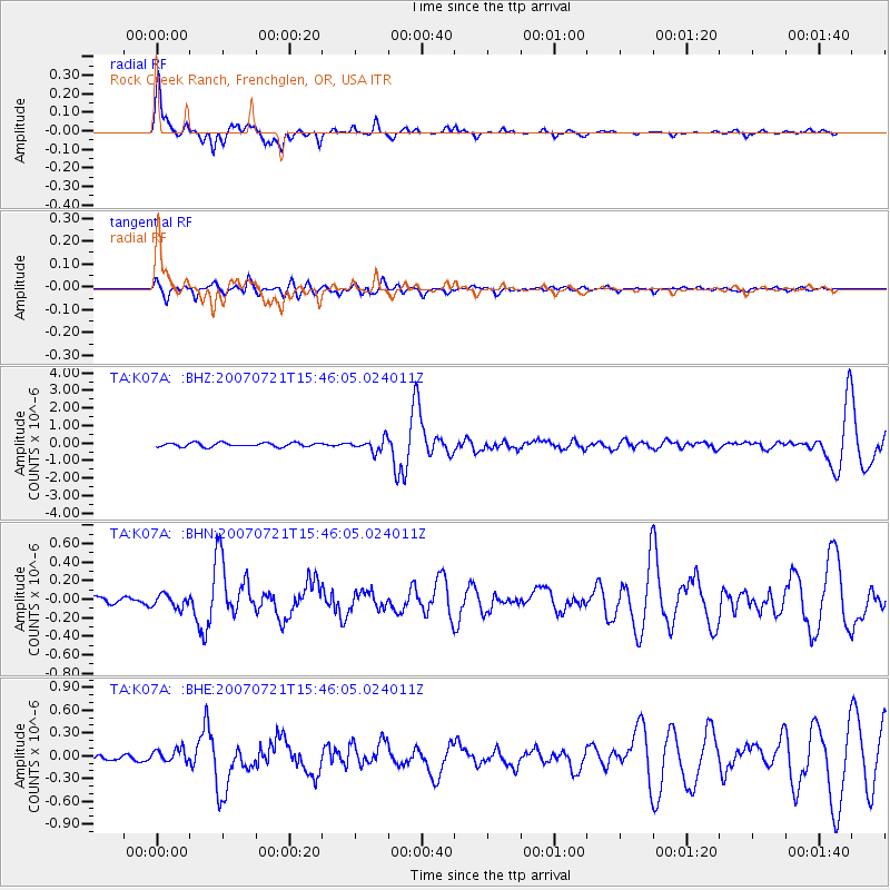
Signal To Noise
| Channel | StoN | STA | LTA |
| TA:K07A: :BHN:20070721T15:46:05.024011Z | 2.2637045 | 7.291154E-8 | 3.2208945E-8 |
| TA:K07A: :BHE:20070721T15:46:05.024011Z | 2.1636658 | 8.957221E-8 | 4.139836E-8 |
| TA:K07A: :BHZ:20070721T15:46:05.024011Z | 3.1026657 | 3.5386125E-7 | 1.1405072E-7 |
| Arrivals |
| Ps | 4.5 SECOND |
| PpPs | 14 SECOND |
| PsPs/PpSs | 19 SECOND |


