You are here: Home > Network List > TA - USArray Transportable Network (new EarthScope stations) Stations List
> Station K07A Rock Creek Ranch, Frenchglen, OR, USA > Earthquake Result Viewer
K07A Rock Creek Ranch, Frenchglen, OR, USA - Earthquake Result Viewer
| Earthquake location: |
Near West Coast Of Honshu, Japan |
| Earthquake latitude/longitude: |
37.5/138.4 |
| Earthquake time(UTC): |
2007/07/16 (197) 01:13:22 GMT |
| Earthquake Depth: |
12 km |
| Earthquake Magnitude: |
6.5 MB, 6.4 MS, 6.6 MW, 6.5 MW |
| Earthquake Catalog/Contributor: |
WHDF/NEIC |
|
| Network: |
TA USArray Transportable Network (new EarthScope stations) |
| Station: |
K07A Rock Creek Ranch, Frenchglen, OR, USA |
| Lat/Lon: |
42.69 N/119.25 W |
| Elevation: |
1407 m |
|
| Distance: |
73.4 deg |
| Az: |
48.72 deg |
| Baz: |
305.878 deg |
| Ray Param: |
0.05299514 |
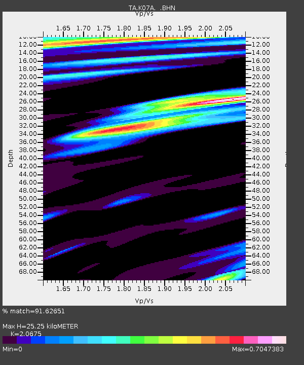
| Estimated Moho Depth: |
25.25 km |
| Estimated Crust Vp/Vs: |
2.07 |
| Assumed Crust Vp: |
6.279 km/s |
| Estimated Crust Vs: |
3.037 km/s |
| Estimated Crust Poisson's Ratio: |
0.35 |
|
| Radial Match: |
91.62651 % |
| Radial Bump: |
400 |
| Transverse Match: |
88.773705 % |
| Transverse Bump: |
400 |
| SOD ConfigId: |
2564 |
| Insert Time: |
2010-03-06 02:51:18.364 +0000 |
| GWidth: |
2.5 |
| Max Bumps: |
400 |
| Tol: |
0.001 |
|
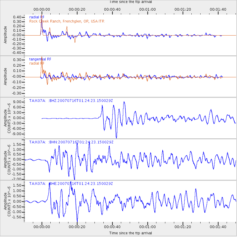
Signal To Noise
| Channel | StoN | STA | LTA |
| TA:K07A: :BHN:20070716T01:24:23.150029Z | 10.829858 | 4.0195368E-7 | 3.7115324E-8 |
| TA:K07A: :BHE:20070716T01:24:23.150029Z | 10.172967 | 6.0616316E-7 | 5.958568E-8 |
| TA:K07A: :BHZ:20070716T01:24:23.150029Z | 28.077547 | 2.3142954E-6 | 8.242513E-8 |
| Arrivals |
| Ps | 4.4 SECOND |
| PpPs | 12 SECOND |
| PsPs/PpSs | 16 SECOND |


