You are here: Home > Network List > TA - USArray Transportable Network (new EarthScope stations) Stations List
> Station K07A Rock Creek Ranch, Frenchglen, OR, USA > Earthquake Result Viewer
K07A Rock Creek Ranch, Frenchglen, OR, USA - Earthquake Result Viewer
| Earthquake location: |
Mariana Islands |
| Earthquake latitude/longitude: |
21.0/144.7 |
| Earthquake time(UTC): |
2007/01/30 (030) 21:37:45 GMT |
| Earthquake Depth: |
30 km |
| Earthquake Magnitude: |
6.3 MB, 6.5 MS, 6.6 MW, 6.5 MW |
| Earthquake Catalog/Contributor: |
WHDF/NEIC |
|
| Network: |
TA USArray Transportable Network (new EarthScope stations) |
| Station: |
K07A Rock Creek Ranch, Frenchglen, OR, USA |
| Lat/Lon: |
42.69 N/119.25 W |
| Elevation: |
1407 m |
|
| Distance: |
80.3 deg |
| Az: |
48.049 deg |
| Baz: |
289.502 deg |
| Ray Param: |
0.048305932 |
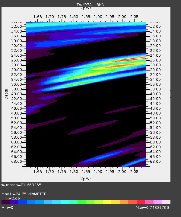
| Estimated Moho Depth: |
24.75 km |
| Estimated Crust Vp/Vs: |
2.09 |
| Assumed Crust Vp: |
6.279 km/s |
| Estimated Crust Vs: |
3.004 km/s |
| Estimated Crust Poisson's Ratio: |
0.35 |
|
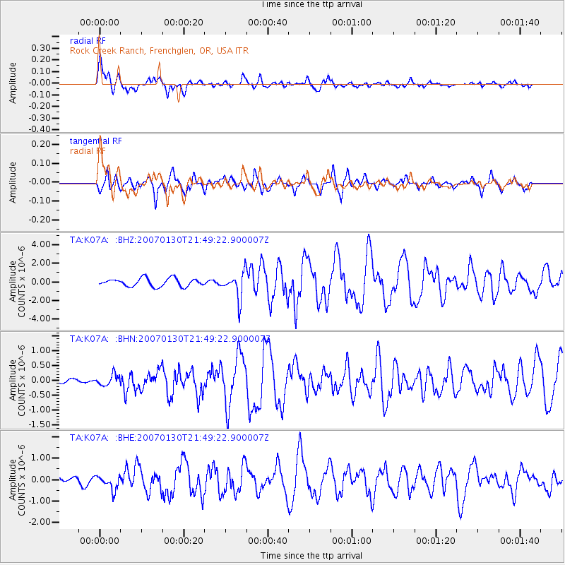
| Radial Match: |
81.660355 % |
| Radial Bump: |
400 |
| Transverse Match: |
70.953606 % |
| Transverse Bump: |
386 |
| SOD ConfigId: |
2564 |
| Insert Time: |
2010-03-06 02:51:39.904 +0000 |
| GWidth: |
2.5 |
| Max Bumps: |
400 |
| Tol: |
0.001 |
|
Signal To Noise
| Channel | StoN | STA | LTA |
| TA:K07A: :BHN:20070130T21:49:22.900007Z | 1.1205075 | 1.8547992E-7 | 1.6553207E-7 |
| TA:K07A: :BHE:20070130T21:49:22.900007Z | 1.2477773 | 3.3342232E-7 | 2.67213E-7 |
| TA:K07A: :BHZ:20070130T21:49:22.900007Z | 3.357137 | 1.4460687E-6 | 4.3074465E-7 |
| Arrivals |
| Ps | 4.4 SECOND |
| PpPs | 12 SECOND |
| PsPs/PpSs | 16 SECOND |


