You are here: Home > Network List > TA - USArray Transportable Network (new EarthScope stations) Stations List
> Station K07A Rock Creek Ranch, Frenchglen, OR, USA > Earthquake Result Viewer
K07A Rock Creek Ranch, Frenchglen, OR, USA - Earthquake Result Viewer
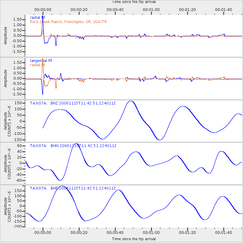
| Earthquake location: |
Kuril Islands |
| Earthquake latitude/longitude: |
46.9/153.7 |
| Earthquake time(UTC): |
2006/11/15 (319) 11:33:23 GMT |
| Earthquake Depth: |
10 km |
| Earthquake Magnitude: |
5.5 MB |
| Earthquake Catalog/Contributor: |
WHDF/NEIC |
|
| Network: |
TA USArray Transportable Network (new EarthScope stations) |
| Station: |
K07A Rock Creek Ranch, Frenchglen, OR, USA |
| Lat/Lon: |
42.69 N/119.25 W |
| Elevation: |
1407 m |
|
| Distance: |
58.8 deg |
| Az: |
59.384 deg |
| Baz: |
306.777 deg |
| Ray Param: |
0.06259466 |
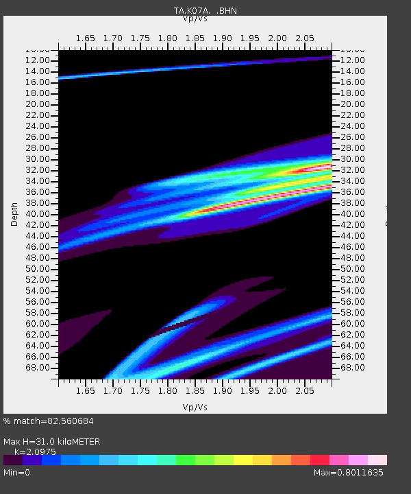
| Estimated Moho Depth: |
31.0 km |
| Estimated Crust Vp/Vs: |
2.10 |
| Assumed Crust Vp: |
6.279 km/s |
| Estimated Crust Vs: |
2.993 km/s |
| Estimated Crust Poisson's Ratio: |
0.35 |
|
| Radial Match: |
82.560684 % |
| Radial Bump: |
400 |
| Transverse Match: |
81.98015 % |
| Transverse Bump: |
394 |
| SOD ConfigId: |
2564 |
| Insert Time: |
2010-03-06 02:51:50.145 +0000 |
| GWidth: |
2.5 |
| Max Bumps: |
400 |
| Tol: |
0.001 |
|
Signal To Noise
| Channel | StoN | STA | LTA |
| TA:K07A: :BHN:20061115T11:42:51.224011Z | 0.6408567 | 3.014343E-5 | 4.7036145E-5 |
| TA:K07A: :BHE:20061115T11:42:51.224011Z | 1.0937797 | 9.108697E-5 | 8.327726E-5 |
| TA:K07A: :BHZ:20061115T11:42:51.224011Z | 3.3395073 | 1.6761305E-4 | 5.0190953E-5 |
| Arrivals |
| Ps | 5.6 SECOND |
| PpPs | 15 SECOND |
| PsPs/PpSs | 20 SECOND |


