You are here: Home > Network List > II - Global Seismograph Network (GSN - IRIS/IDA) Stations List
> Station NIL Nilore, Pakistan > Earthquake Result Viewer
NIL Nilore, Pakistan - Earthquake Result Viewer
| Earthquake location: |
New Ireland Region, P.N.G. |
| Earthquake latitude/longitude: |
-5.3/153.2 |
| Earthquake time(UTC): |
2016/01/26 (026) 03:10:23 GMT |
| Earthquake Depth: |
44 km |
| Earthquake Magnitude: |
5.8 MWP |
| Earthquake Catalog/Contributor: |
NEIC PDE/NEIC COMCAT |
|
| Network: |
II Global Seismograph Network (GSN - IRIS/IDA) |
| Station: |
NIL Nilore, Pakistan |
| Lat/Lon: |
33.65 N/73.27 E |
| Elevation: |
629 m |
|
| Distance: |
84.6 deg |
| Az: |
304.419 deg |
| Baz: |
100.025 deg |
| Ray Param: |
0.045322992 |
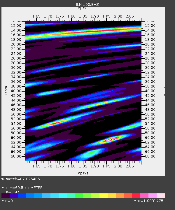
| Estimated Moho Depth: |
60.5 km |
| Estimated Crust Vp/Vs: |
1.97 |
| Assumed Crust Vp: |
6.242 km/s |
| Estimated Crust Vs: |
3.169 km/s |
| Estimated Crust Poisson's Ratio: |
0.33 |
|
| Radial Match: |
87.825485 % |
| Radial Bump: |
400 |
| Transverse Match: |
85.07233 % |
| Transverse Bump: |
400 |
| SOD ConfigId: |
1399611 |
| Insert Time: |
2016-02-09 03:39:13.368 +0000 |
| GWidth: |
2.5 |
| Max Bumps: |
400 |
| Tol: |
0.001 |
|

Signal To Noise
| Channel | StoN | STA | LTA |
| II:NIL:00:BHZ:20160126T03:22:20.919026Z | 9.509863 | 1.2790234E-6 | 1.3449441E-7 |
| II:NIL:00:BH1:20160126T03:22:20.919026Z | 0.8154649 | 7.268074E-8 | 8.912798E-8 |
| II:NIL:00:BH2:20160126T03:22:20.919026Z | 2.4831111 | 3.361243E-7 | 1.3536417E-7 |
| Arrivals |
| Ps | 9.6 SECOND |
| PpPs | 28 SECOND |
| PsPs/PpSs | 38 SECOND |


