You are here: Home > Network List > TA - USArray Transportable Network (new EarthScope stations) Stations List
> Station K07A Rock Creek Ranch, Frenchglen, OR, USA > Earthquake Result Viewer
K07A Rock Creek Ranch, Frenchglen, OR, USA - Earthquake Result Viewer
| Earthquake location: |
Tonga Islands |
| Earthquake latitude/longitude: |
-15.2/-173.6 |
| Earthquake time(UTC): |
2006/07/07 (188) 07:26:12 GMT |
| Earthquake Depth: |
35 km |
| Earthquake Magnitude: |
5.7 MB, 5.9 MS, 6.0 MW, 6.0 MW |
| Earthquake Catalog/Contributor: |
WHDF/NEIC |
|
| Network: |
TA USArray Transportable Network (new EarthScope stations) |
| Station: |
K07A Rock Creek Ranch, Frenchglen, OR, USA |
| Lat/Lon: |
42.69 N/119.25 W |
| Elevation: |
1407 m |
|
| Distance: |
76.2 deg |
| Az: |
38.094 deg |
| Baz: |
233.874 deg |
| Ray Param: |
0.05108707 |
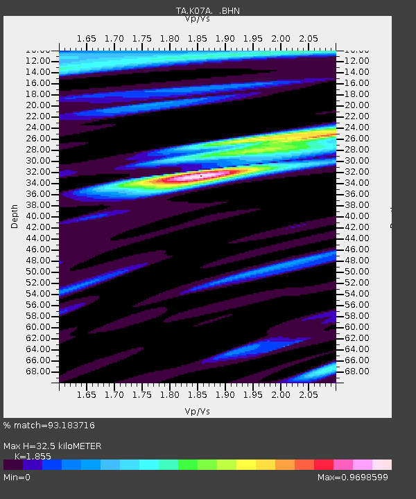
| Estimated Moho Depth: |
32.5 km |
| Estimated Crust Vp/Vs: |
1.86 |
| Assumed Crust Vp: |
6.279 km/s |
| Estimated Crust Vs: |
3.385 km/s |
| Estimated Crust Poisson's Ratio: |
0.30 |
|
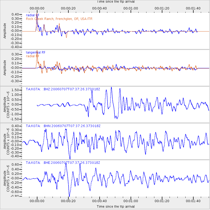
| Radial Match: |
93.183716 % |
| Radial Bump: |
400 |
| Transverse Match: |
81.68005 % |
| Transverse Bump: |
400 |
| SOD ConfigId: |
5423 |
| Insert Time: |
2010-03-06 02:52:00.911 +0000 |
| GWidth: |
2.5 |
| Max Bumps: |
400 |
| Tol: |
0.001 |
|
Signal To Noise
| Channel | StoN | STA | LTA |
| TA:K07A: :BHN:20060707T07:37:26.373018Z | 2.722013 | 1.2212104E-7 | 4.4864233E-8 |
| TA:K07A: :BHE:20060707T07:37:26.373018Z | 3.2565875 | 1.2321166E-7 | 3.7834592E-8 |
| TA:K07A: :BHZ:20060707T07:37:26.373018Z | 5.8009863 | 4.935424E-7 | 8.507906E-8 |
| Arrivals |
| Ps | 4.6 SECOND |
| PpPs | 14 SECOND |
| PsPs/PpSs | 19 SECOND |


