You are here: Home > Network List > AV - Alaska Volcano Observatory Stations List
> Station AMKA Regional Station, Amchitka Island, Alaska > Earthquake Result Viewer
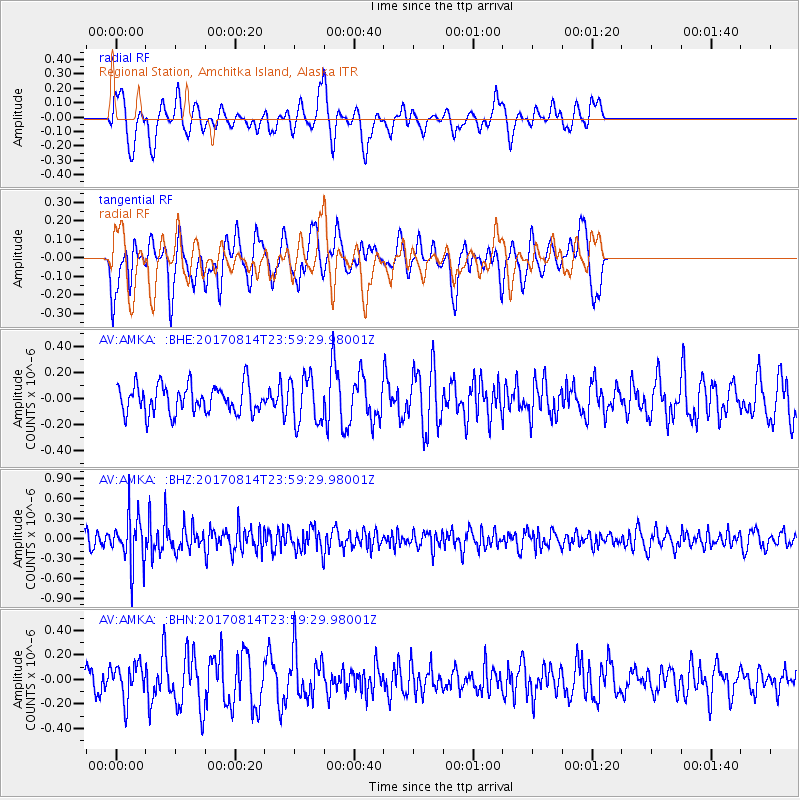
AMKA Regional Station, Amchitka Island, Alaska - Earthquake Result Viewer
*The percent match for this event was below the threshold and hence no stack was calculated.
| Earthquake location: |
Irian Jaya, Indonesia |
| Earthquake latitude/longitude: |
-3.9/140.2 |
| Earthquake time(UTC): |
2017/08/14 (226) 23:49:29 GMT |
| Earthquake Depth: |
36 km |
| Earthquake Magnitude: |
5.5 mb |
| Earthquake Catalog/Contributor: |
NEIC PDE/us |
|
| Network: |
AV Alaska Volcano Observatory |
| Station: |
AMKA Regional Station, Amchitka Island, Alaska |
| Lat/Lon: |
51.38 N/179.30 E |
| Elevation: |
116 m |
|
| Distance: |
64.3 deg |
| Az: |
25.995 deg |
| Baz: |
224.248 deg |
| Ray Param: |
$rayparam |
*The percent match for this event was below the threshold and hence was not used in the summary stack. |
|
| Radial Match: |
61.27908 % |
| Radial Bump: |
400 |
| Transverse Match: |
66.34507 % |
| Transverse Bump: |
400 |
| SOD ConfigId: |
13570011 |
| Insert Time: |
2019-04-28 14:34:59.349 +0000 |
| GWidth: |
2.5 |
| Max Bumps: |
400 |
| Tol: |
0.001 |
|
Signal To Noise
| Channel | StoN | STA | LTA |
| AV:AMKA: :BHZ:20170814T23:59:29.98001Z | 2.539929 | 3.777737E-7 | 1.4873396E-7 |
| AV:AMKA: :BHN:20170814T23:59:29.98001Z | 1.6057951 | 1.4097998E-7 | 8.77945E-8 |
| AV:AMKA: :BHE:20170814T23:59:29.98001Z | 1.6651237 | 1.7630973E-7 | 1.05883856E-7 |
| Arrivals |
| Ps | |
| PpPs | |
| PsPs/PpSs | |


