You are here: Home > Network List > TA - USArray Transportable Network (new EarthScope stations) Stations List
> Station K07A Rock Creek Ranch, Frenchglen, OR, USA > Earthquake Result Viewer
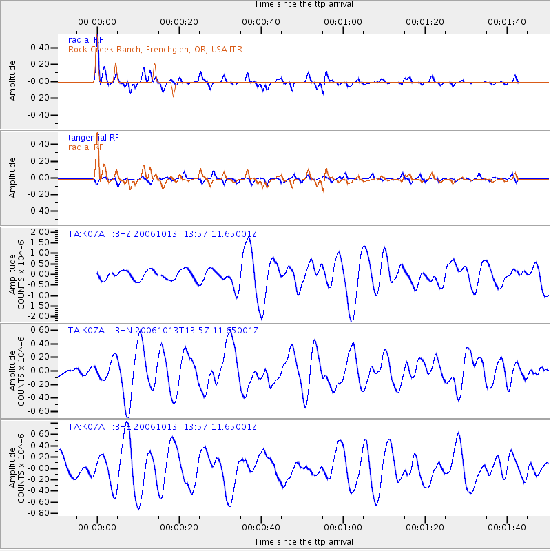
K07A Rock Creek Ranch, Frenchglen, OR, USA - Earthquake Result Viewer
| Earthquake location: |
Kuril Islands |
| Earthquake latitude/longitude: |
46.3/153.3 |
| Earthquake time(UTC): |
2006/10/13 (286) 13:47:39 GMT |
| Earthquake Depth: |
8.0 km |
| Earthquake Magnitude: |
5.5 MB, 5.8 MS, 6.3 MW, 5.8 MW |
| Earthquake Catalog/Contributor: |
WHDF/NEIC |
|
| Network: |
TA USArray Transportable Network (new EarthScope stations) |
| Station: |
K07A Rock Creek Ranch, Frenchglen, OR, USA |
| Lat/Lon: |
42.69 N/119.25 W |
| Elevation: |
1407 m |
|
| Distance: |
59.4 deg |
| Az: |
58.839 deg |
| Baz: |
306.354 deg |
| Ray Param: |
0.06221681 |
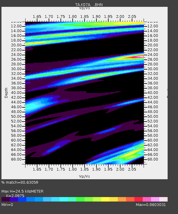
| Estimated Moho Depth: |
24.5 km |
| Estimated Crust Vp/Vs: |
2.10 |
| Assumed Crust Vp: |
6.279 km/s |
| Estimated Crust Vs: |
2.993 km/s |
| Estimated Crust Poisson's Ratio: |
0.35 |
|
| Radial Match: |
80.63059 % |
| Radial Bump: |
400 |
| Transverse Match: |
55.49124 % |
| Transverse Bump: |
370 |
| SOD ConfigId: |
2665 |
| Insert Time: |
2010-03-06 02:52:08.069 +0000 |
| GWidth: |
2.5 |
| Max Bumps: |
400 |
| Tol: |
0.001 |
|
Signal To Noise
| Channel | StoN | STA | LTA |
| TA:K07A: :BHN:20061013T13:57:11.65001Z | 1.1831937 | 1.4420947E-7 | 1.2188154E-7 |
| TA:K07A: :BHE:20061013T13:57:11.65001Z | 1.3594161 | 2.7374423E-7 | 2.0136896E-7 |
| TA:K07A: :BHZ:20061013T13:57:11.65001Z | 2.1490986 | 4.6880257E-7 | 2.1813914E-7 |
| Arrivals |
| Ps | 4.4 SECOND |
| PpPs | 12 SECOND |
| PsPs/PpSs | 16 SECOND |


