You are here: Home > Network List > TA - USArray Transportable Network (new EarthScope stations) Stations List
> Station K07A Rock Creek Ranch, Frenchglen, OR, USA > Earthquake Result Viewer
K07A Rock Creek Ranch, Frenchglen, OR, USA - Earthquake Result Viewer
| Earthquake location: |
Kuril Islands |
| Earthquake latitude/longitude: |
46.5/153.2 |
| Earthquake time(UTC): |
2006/10/01 (274) 09:06:02 GMT |
| Earthquake Depth: |
19 km |
| Earthquake Magnitude: |
6.1 MB, 6.4 MS, 6.6 MW, 6.5 MW |
| Earthquake Catalog/Contributor: |
WHDF/NEIC |
|
| Network: |
TA USArray Transportable Network (new EarthScope stations) |
| Station: |
K07A Rock Creek Ranch, Frenchglen, OR, USA |
| Lat/Lon: |
42.69 N/119.25 W |
| Elevation: |
1407 m |
|
| Distance: |
59.3 deg |
| Az: |
58.93 deg |
| Baz: |
306.587 deg |
| Ray Param: |
0.06225062 |
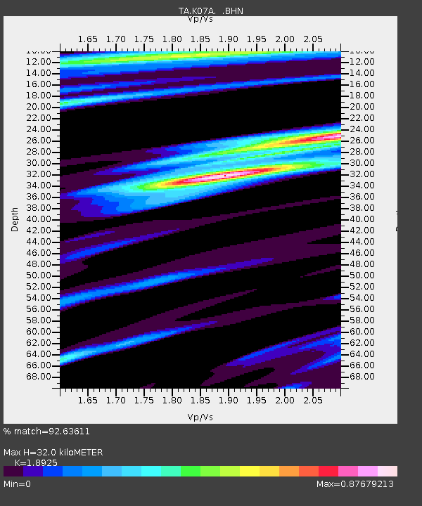
| Estimated Moho Depth: |
32.0 km |
| Estimated Crust Vp/Vs: |
1.89 |
| Assumed Crust Vp: |
6.279 km/s |
| Estimated Crust Vs: |
3.318 km/s |
| Estimated Crust Poisson's Ratio: |
0.31 |
|
| Radial Match: |
92.63611 % |
| Radial Bump: |
344 |
| Transverse Match: |
82.494286 % |
| Transverse Bump: |
382 |
| SOD ConfigId: |
2665 |
| Insert Time: |
2010-03-06 02:52:14.980 +0000 |
| GWidth: |
2.5 |
| Max Bumps: |
400 |
| Tol: |
0.001 |
|

Signal To Noise
| Channel | StoN | STA | LTA |
| TA:K07A: :BHN:20061001T09:15:31.799004Z | 0.9421467 | 1.7176804E-7 | 1.823156E-7 |
| TA:K07A: :BHE:20061001T09:15:31.799004Z | 2.1342847 | 2.8978835E-7 | 1.3577774E-7 |
| TA:K07A: :BHZ:20061001T09:15:31.799004Z | 3.1428888 | 7.5568283E-7 | 2.4044212E-7 |
| Arrivals |
| Ps | 4.7 SECOND |
| PpPs | 14 SECOND |
| PsPs/PpSs | 19 SECOND |


