You are here: Home > Network List > TA - USArray Transportable Network (new EarthScope stations) Stations List
> Station E18K Tukpahlearik Creek, AK, USA > Earthquake Result Viewer
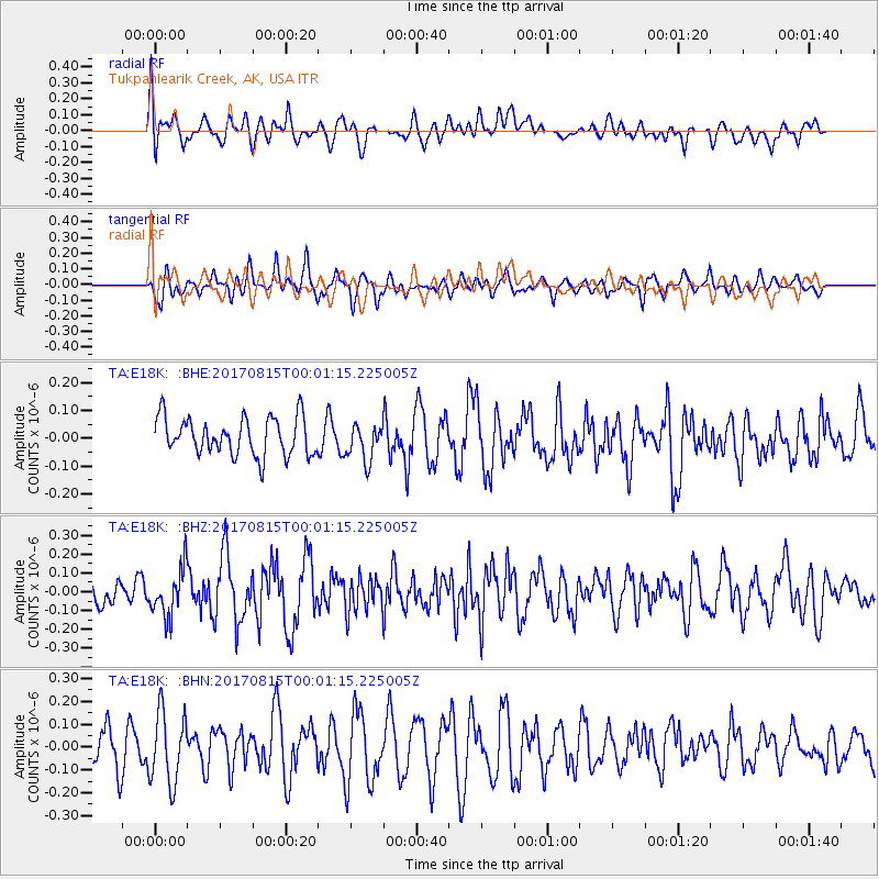
E18K Tukpahlearik Creek, AK, USA - Earthquake Result Viewer
*The percent match for this event was below the threshold and hence no stack was calculated.
| Earthquake location: |
Irian Jaya, Indonesia |
| Earthquake latitude/longitude: |
-3.9/140.2 |
| Earthquake time(UTC): |
2017/08/14 (226) 23:49:29 GMT |
| Earthquake Depth: |
36 km |
| Earthquake Magnitude: |
5.5 mb |
| Earthquake Catalog/Contributor: |
NEIC PDE/us |
|
| Network: |
TA USArray Transportable Network (new EarthScope stations) |
| Station: |
E18K Tukpahlearik Creek, AK, USA |
| Lat/Lon: |
67.42 N/160.60 W |
| Elevation: |
297 m |
|
| Distance: |
82.2 deg |
| Az: |
19.552 deg |
| Baz: |
239.851 deg |
| Ray Param: |
$rayparam |
*The percent match for this event was below the threshold and hence was not used in the summary stack. |
|
| Radial Match: |
40.756798 % |
| Radial Bump: |
400 |
| Transverse Match: |
56.789677 % |
| Transverse Bump: |
400 |
| SOD ConfigId: |
13570011 |
| Insert Time: |
2019-04-28 14:36:38.013 +0000 |
| GWidth: |
2.5 |
| Max Bumps: |
400 |
| Tol: |
0.001 |
|
Signal To Noise
| Channel | StoN | STA | LTA |
| TA:E18K: :BHZ:20170815T00:01:15.225005Z | 1.4627953 | 1.2569502E-7 | 8.592797E-8 |
| TA:E18K: :BHN:20170815T00:01:15.225005Z | 2.586063 | 1.5718422E-7 | 6.078128E-8 |
| TA:E18K: :BHE:20170815T00:01:15.225005Z | 1.0337774 | 6.9977254E-8 | 6.7690834E-8 |
| Arrivals |
| Ps | |
| PpPs | |
| PsPs/PpSs | |


