You are here: Home > Network List > TA - USArray Transportable Network (new EarthScope stations) Stations List
> Station 425A Indio Mountain, Van Horn, TX, USA > Earthquake Result Viewer
425A Indio Mountain, Van Horn, TX, USA - Earthquake Result Viewer
| Earthquake location: |
Andreanof Islands, Aleutian Is. |
| Earthquake latitude/longitude: |
51.9/-179.2 |
| Earthquake time(UTC): |
2008/04/16 (107) 05:54:19 GMT |
| Earthquake Depth: |
13 km |
| Earthquake Magnitude: |
6.1 MB, 6.5 MS, 6.6 MW, 6.6 MW |
| Earthquake Catalog/Contributor: |
WHDF/NEIC |
|
| Network: |
TA USArray Transportable Network (new EarthScope stations) |
| Station: |
425A Indio Mountain, Van Horn, TX, USA |
| Lat/Lon: |
30.79 N/104.99 W |
| Elevation: |
1337 m |
|
| Distance: |
57.0 deg |
| Az: |
80.968 deg |
| Baz: |
314.652 deg |
| Ray Param: |
0.06378606 |
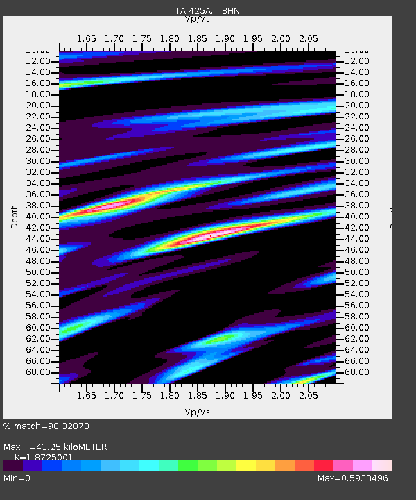
| Estimated Moho Depth: |
43.25 km |
| Estimated Crust Vp/Vs: |
1.87 |
| Assumed Crust Vp: |
6.361 km/s |
| Estimated Crust Vs: |
3.397 km/s |
| Estimated Crust Poisson's Ratio: |
0.30 |
|
| Radial Match: |
90.32073 % |
| Radial Bump: |
376 |
| Transverse Match: |
86.34054 % |
| Transverse Bump: |
400 |
| SOD ConfigId: |
2504 |
| Insert Time: |
2010-03-06 02:52:43.175 +0000 |
| GWidth: |
2.5 |
| Max Bumps: |
400 |
| Tol: |
0.001 |
|

Signal To Noise
| Channel | StoN | STA | LTA |
| TA:425A: :BHN:20080416T06:03:33.674009Z | 3.1444223 | 5.447306E-7 | 1.732371E-7 |
| TA:425A: :BHE:20080416T06:03:33.674009Z | 1.2944596 | 2.6604124E-7 | 2.0552302E-7 |
| TA:425A: :BHZ:20080416T06:03:33.674009Z | 0.7805932 | 1.3359397E-7 | 1.7114417E-7 |
| Arrivals |
| Ps | 6.2 SECOND |
| PpPs | 19 SECOND |
| PsPs/PpSs | 25 SECOND |


