You are here: Home > Network List > TA - USArray Transportable Network (new EarthScope stations) Stations List
> Station 425A Indio Mountain, Van Horn, TX, USA > Earthquake Result Viewer
425A Indio Mountain, Van Horn, TX, USA - Earthquake Result Viewer
| Earthquake location: |
Santa Cruz Islands Region |
| Earthquake latitude/longitude: |
-11.0/164.5 |
| Earthquake time(UTC): |
2008/07/19 (201) 09:27:01 GMT |
| Earthquake Depth: |
11 km |
| Earthquake Magnitude: |
6.1 MB, 6.4 MS, 6.6 MW, 6.6 MW |
| Earthquake Catalog/Contributor: |
WHDF/NEIC |
|
| Network: |
TA USArray Transportable Network (new EarthScope stations) |
| Station: |
425A Indio Mountain, Van Horn, TX, USA |
| Lat/Lon: |
30.79 N/104.99 W |
| Elevation: |
1337 m |
|
| Distance: |
96.0 deg |
| Az: |
59.917 deg |
| Baz: |
260.789 deg |
| Ray Param: |
0.0406315 |
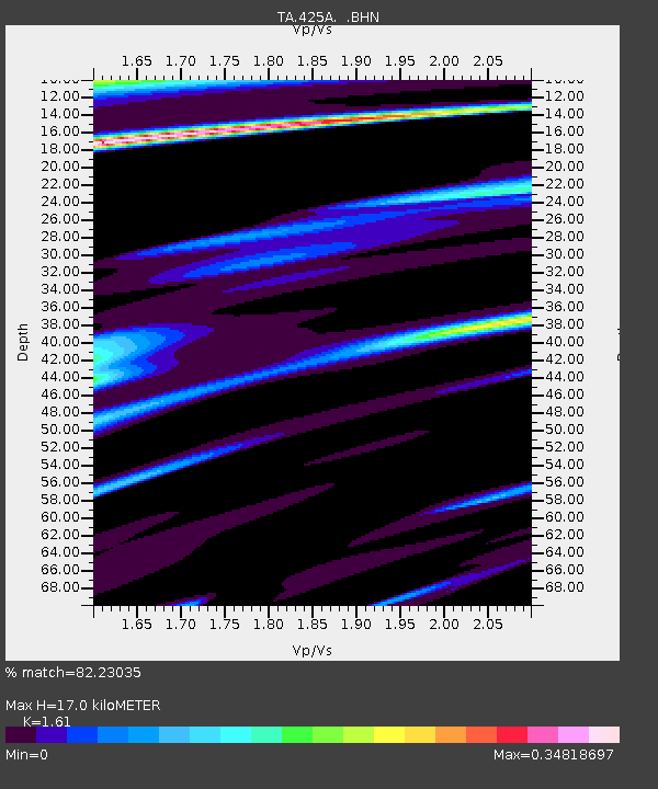
| Estimated Moho Depth: |
17.0 km |
| Estimated Crust Vp/Vs: |
1.61 |
| Assumed Crust Vp: |
6.361 km/s |
| Estimated Crust Vs: |
3.951 km/s |
| Estimated Crust Poisson's Ratio: |
0.19 |
|
| Radial Match: |
82.23035 % |
| Radial Bump: |
400 |
| Transverse Match: |
74.73357 % |
| Transverse Bump: |
400 |
| SOD ConfigId: |
2658 |
| Insert Time: |
2010-03-06 02:53:22.302 +0000 |
| GWidth: |
2.5 |
| Max Bumps: |
400 |
| Tol: |
0.001 |
|
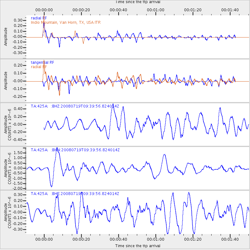
Signal To Noise
| Channel | StoN | STA | LTA |
| TA:425A: :BHN:20080719T09:39:56.824014Z | 13.238288 | 8.553942E-7 | 6.461517E-8 |
| TA:425A: :BHE:20080719T09:39:56.824014Z | 0.89388883 | 7.609081E-8 | 8.512334E-8 |
| TA:425A: :BHZ:20080719T09:39:56.824014Z | 1.8769051 | 1.7532099E-7 | 9.340962E-8 |
| Arrivals |
| Ps | 1.7 SECOND |
| PpPs | 6.8 SECOND |
| PsPs/PpSs | 8.5 SECOND |


