You are here: Home > Network List > TA - USArray Transportable Network (new EarthScope stations) Stations List
> Station 425A Indio Mountain, Van Horn, TX, USA > Earthquake Result Viewer
425A Indio Mountain, Van Horn, TX, USA - Earthquake Result Viewer

| Earthquake location: |
Kermadec Islands Region |
| Earthquake latitude/longitude: |
-27.4/-176.3 |
| Earthquake time(UTC): |
2009/02/18 (049) 21:53:45 GMT |
| Earthquake Depth: |
25 km |
| Earthquake Magnitude: |
6.8 MB, 7.2 MS, 6.9 MW, 6.9 MW |
| Earthquake Catalog/Contributor: |
WHDF/NEIC |
|
| Network: |
TA USArray Transportable Network (new EarthScope stations) |
| Station: |
425A Indio Mountain, Van Horn, TX, USA |
| Lat/Lon: |
30.79 N/104.99 W |
| Elevation: |
1337 m |
|
| Distance: |
89.3 deg |
| Az: |
54.629 deg |
| Baz: |
237.377 deg |
| Ray Param: |
0.04188932 |
| Estimated Moho Depth: |
43.25 km |
| Estimated Crust Vp/Vs: |
1.60 |
| Assumed Crust Vp: |
6.361 km/s |
| Estimated Crust Vs: |
3.975 km/s |
| Estimated Crust Poisson's Ratio: |
0.18 |
|
| Radial Match: |
97.13408 % |
| Radial Bump: |
258 |
| Transverse Match: |
90.40303 % |
| Transverse Bump: |
366 |
| SOD ConfigId: |
2658 |
| Insert Time: |
2010-03-06 02:53:25.200 +0000 |
| GWidth: |
2.5 |
| Max Bumps: |
400 |
| Tol: |
0.001 |
|
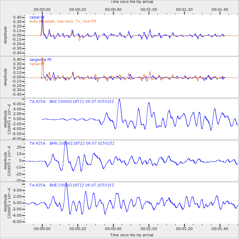
Signal To Noise
| Channel | StoN | STA | LTA |
| TA:425A: :BHN:20090218T22:06:07.925015Z | 15.930566 | 3.4216723E-6 | 2.1478661E-7 |
| TA:425A: :BHE:20090218T22:06:07.925015Z | 5.5740986 | 7.770841E-7 | 1.3940982E-7 |
| TA:425A: :BHZ:20090218T22:06:07.925015Z | 5.1160564 | 9.918763E-7 | 1.9387517E-7 |
| Arrivals |
| Ps | 4.2 SECOND |
| PpPs | 17 SECOND |
| PsPs/PpSs | 21 SECOND |


