You are here: Home > Network List > TA - USArray Transportable Network (new EarthScope stations) Stations List
> Station 425A Indio Mountain, Van Horn, TX, USA > Earthquake Result Viewer
425A Indio Mountain, Van Horn, TX, USA - Earthquake Result Viewer
| Earthquake location: |
Tonga Islands |
| Earthquake latitude/longitude: |
-16.3/-173.5 |
| Earthquake time(UTC): |
2009/10/02 (275) 01:07:39 GMT |
| Earthquake Depth: |
8.0 km |
| Earthquake Magnitude: |
6.1 MB, 6.0 MS, 6.1 MW, 6.1 MW |
| Earthquake Catalog/Contributor: |
WHDF/NEIC |
|
| Network: |
TA USArray Transportable Network (new EarthScope stations) |
| Station: |
425A Indio Mountain, Van Horn, TX, USA |
| Lat/Lon: |
30.79 N/104.99 W |
| Elevation: |
1337 m |
|
| Distance: |
80.8 deg |
| Az: |
54.21 deg |
| Baz: |
244.823 deg |
| Ray Param: |
0.048065726 |
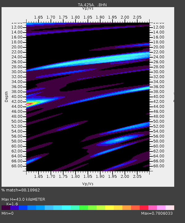
| Estimated Moho Depth: |
43.0 km |
| Estimated Crust Vp/Vs: |
1.60 |
| Assumed Crust Vp: |
6.361 km/s |
| Estimated Crust Vs: |
3.975 km/s |
| Estimated Crust Poisson's Ratio: |
0.18 |
|
| Radial Match: |
88.18962 % |
| Radial Bump: |
400 |
| Transverse Match: |
67.68845 % |
| Transverse Bump: |
400 |
| SOD ConfigId: |
2622 |
| Insert Time: |
2010-03-06 02:53:48.542 +0000 |
| GWidth: |
2.5 |
| Max Bumps: |
400 |
| Tol: |
0.001 |
|

Signal To Noise
| Channel | StoN | STA | LTA |
| TA:425A: :BHN:20091002T01:19:21.650015Z | 2.3815064 | 4.0601086E-7 | 1.704849E-7 |
| TA:425A: :BHE:20091002T01:19:21.650015Z | 1.3421395 | 1.4550704E-7 | 1.0841425E-7 |
| TA:425A: :BHZ:20091002T01:19:21.650015Z | 1.5671405 | 1.7653774E-7 | 1.1264959E-7 |
| Arrivals |
| Ps | 4.2 SECOND |
| PpPs | 17 SECOND |
| PsPs/PpSs | 21 SECOND |


