You are here: Home > Network List > TA - USArray Transportable Network (new EarthScope stations) Stations List
> Station 425A Indio Mountain, Van Horn, TX, USA > Earthquake Result Viewer
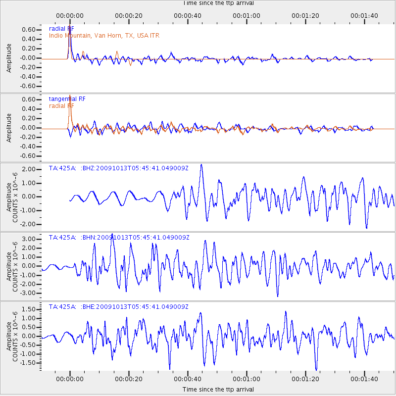
425A Indio Mountain, Van Horn, TX, USA - Earthquake Result Viewer

| Earthquake location: |
Fox Islands, Aleutian Islands |
| Earthquake latitude/longitude: |
52.8/-167.0 |
| Earthquake time(UTC): |
2009/10/13 (286) 05:37:23 GMT |
| Earthquake Depth: |
24 km |
| Earthquake Magnitude: |
6.0 MB, 6.1 MS, 6.5 MW, 6.5 MW |
| Earthquake Catalog/Contributor: |
WHDF/NEIC |
|
| Network: |
TA USArray Transportable Network (new EarthScope stations) |
| Station: |
425A Indio Mountain, Van Horn, TX, USA |
| Lat/Lon: |
30.79 N/104.99 W |
| Elevation: |
1337 m |
|
| Distance: |
49.5 deg |
| Az: |
90.84 deg |
| Baz: |
315.073 deg |
| Ray Param: |
0.068646386 |
| Estimated Moho Depth: |
27.25 km |
| Estimated Crust Vp/Vs: |
2.01 |
| Assumed Crust Vp: |
6.361 km/s |
| Estimated Crust Vs: |
3.168 km/s |
| Estimated Crust Poisson's Ratio: |
0.33 |
|
| Radial Match: |
84.55554 % |
| Radial Bump: |
349 |
| Transverse Match: |
79.00285 % |
| Transverse Bump: |
400 |
| SOD ConfigId: |
2622 |
| Insert Time: |
2010-03-06 02:53:56.782 +0000 |
| GWidth: |
2.5 |
| Max Bumps: |
400 |
| Tol: |
0.001 |
|
Signal To Noise
| Channel | StoN | STA | LTA |
| TA:425A: :BHN:20091013T05:45:41.049009Z | 1.645187 | 4.6715311E-7 | 2.8395138E-7 |
| TA:425A: :BHE:20091013T05:45:41.049009Z | 0.9145857 | 1.8987535E-7 | 2.0760804E-7 |
| TA:425A: :BHZ:20091013T05:45:41.049009Z | 1.7250462 | 4.906179E-7 | 2.8440857E-7 |
| Arrivals |
| Ps | 4.5 SECOND |
| PpPs | 12 SECOND |
| PsPs/PpSs | 17 SECOND |


