You are here: Home > Network List > TA - USArray Transportable Network (new EarthScope stations) Stations List
> Station 425A Indio Mountain, Van Horn, TX, USA > Earthquake Result Viewer
425A Indio Mountain, Van Horn, TX, USA - Earthquake Result Viewer
| Earthquake location: |
Kuril Islands |
| Earthquake latitude/longitude: |
46.0/151.4 |
| Earthquake time(UTC): |
2009/04/18 (108) 19:17:58 GMT |
| Earthquake Depth: |
35 km |
| Earthquake Magnitude: |
6.3 MB, 6.3 MS, 6.6 MW, 6.4 MW |
| Earthquake Catalog/Contributor: |
WHDF/NEIC |
|
| Network: |
TA USArray Transportable Network (new EarthScope stations) |
| Station: |
425A Indio Mountain, Van Horn, TX, USA |
| Lat/Lon: |
30.79 N/104.99 W |
| Elevation: |
1337 m |
|
| Distance: |
77.0 deg |
| Az: |
59.136 deg |
| Baz: |
315.965 deg |
| Ray Param: |
0.05054432 |
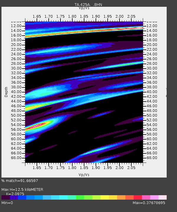
| Estimated Moho Depth: |
12.5 km |
| Estimated Crust Vp/Vs: |
2.10 |
| Assumed Crust Vp: |
6.361 km/s |
| Estimated Crust Vs: |
3.032 km/s |
| Estimated Crust Poisson's Ratio: |
0.35 |
|
| Radial Match: |
91.66597 % |
| Radial Bump: |
400 |
| Transverse Match: |
78.03574 % |
| Transverse Bump: |
400 |
| SOD ConfigId: |
2658 |
| Insert Time: |
2010-03-06 02:54:11.158 +0000 |
| GWidth: |
2.5 |
| Max Bumps: |
400 |
| Tol: |
0.001 |
|
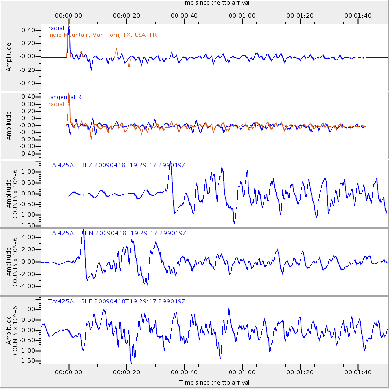
Signal To Noise
| Channel | StoN | STA | LTA |
| TA:425A: :BHN:20090418T19:29:17.299019Z | 13.221613 | 1.4972269E-6 | 1.13240866E-7 |
| TA:425A: :BHE:20090418T19:29:17.299019Z | 1.4789672 | 2.9948433E-7 | 2.0249558E-7 |
| TA:425A: :BHZ:20090418T19:29:17.299019Z | 4.0000377 | 3.3536082E-7 | 8.383942E-8 |
| Arrivals |
| Ps | 2.2 SECOND |
| PpPs | 5.9 SECOND |
| PsPs/PpSs | 8.1 SECOND |


