You are here: Home > Network List > TA - USArray Transportable Network (new EarthScope stations) Stations List
> Station D25K Kavik River, AK, USA > Earthquake Result Viewer
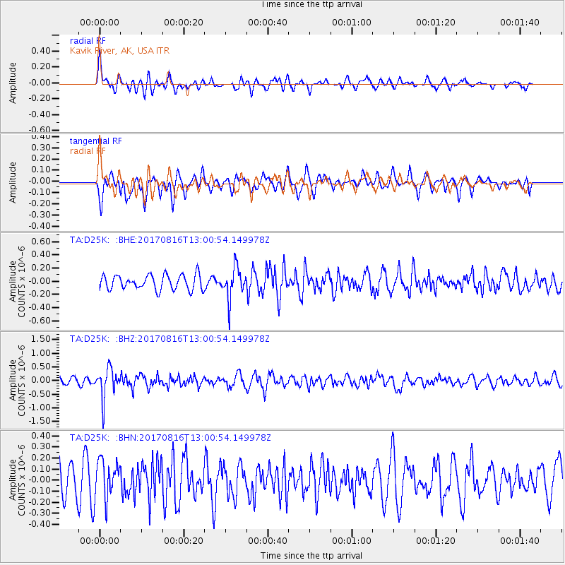
D25K Kavik River, AK, USA - Earthquake Result Viewer
*The percent match for this event was below the threshold and hence no stack was calculated.
| Earthquake location: |
Northwest Of Ryukyu Islands |
| Earthquake latitude/longitude: |
28.6/127.9 |
| Earthquake time(UTC): |
2017/08/16 (228) 12:51:25 GMT |
| Earthquake Depth: |
197 km |
| Earthquake Magnitude: |
5.7 Mww |
| Earthquake Catalog/Contributor: |
NEIC PDE/us |
|
| Network: |
TA USArray Transportable Network (new EarthScope stations) |
| Station: |
D25K Kavik River, AK, USA |
| Lat/Lon: |
69.32 N/146.38 W |
| Elevation: |
770 m |
|
| Distance: |
62.0 deg |
| Az: |
23.647 deg |
| Baz: |
277.013 deg |
| Ray Param: |
$rayparam |
*The percent match for this event was below the threshold and hence was not used in the summary stack. |
|
| Radial Match: |
62.683968 % |
| Radial Bump: |
400 |
| Transverse Match: |
55.13895 % |
| Transverse Bump: |
400 |
| SOD ConfigId: |
13570011 |
| Insert Time: |
2019-04-28 14:57:49.106 +0000 |
| GWidth: |
2.5 |
| Max Bumps: |
400 |
| Tol: |
0.001 |
|
Signal To Noise
| Channel | StoN | STA | LTA |
| TA:D25K: :BHZ:20170816T13:00:54.149978Z | 4.297461 | 5.470841E-7 | 1.2730402E-7 |
| TA:D25K: :BHN:20170816T13:00:54.149978Z | 0.77165467 | 1.6723199E-7 | 2.167187E-7 |
| TA:D25K: :BHE:20170816T13:00:54.149978Z | 2.2097151 | 2.4534725E-7 | 1.1103117E-7 |
| Arrivals |
| Ps | |
| PpPs | |
| PsPs/PpSs | |


