You are here: Home > Network List > TA - USArray Transportable Network (new EarthScope stations) Stations List
> Station 425A Indio Mountain, Van Horn, TX, USA > Earthquake Result Viewer
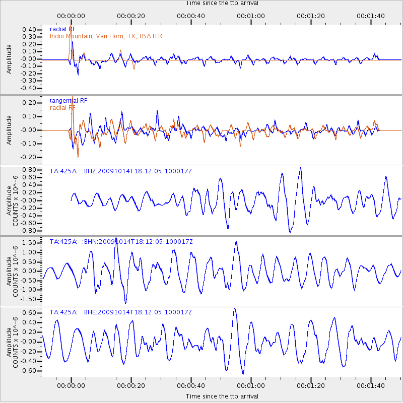
425A Indio Mountain, Van Horn, TX, USA - Earthquake Result Viewer
*The percent match for this event was below the threshold and hence no stack was calculated.
| Earthquake location: |
Samoa Islands Region |
| Earthquake latitude/longitude: |
-14.9/-174.8 |
| Earthquake time(UTC): |
2009/10/14 (287) 18:00:21 GMT |
| Earthquake Depth: |
10 km |
| Earthquake Magnitude: |
5.7 MB, 6.0 MS, 6.3 MW, 6.2 MW |
| Earthquake Catalog/Contributor: |
WHDF/NEIC |
|
| Network: |
TA USArray Transportable Network (new EarthScope stations) |
| Station: |
425A Indio Mountain, Van Horn, TX, USA |
| Lat/Lon: |
30.79 N/104.99 W |
| Elevation: |
1337 m |
|
| Distance: |
81.0 deg |
| Az: |
54.879 deg |
| Baz: |
246.757 deg |
| Ray Param: |
$rayparam |
*The percent match for this event was below the threshold and hence was not used in the summary stack. |
|
| Radial Match: |
67.38475 % |
| Radial Bump: |
400 |
| Transverse Match: |
60.68678 % |
| Transverse Bump: |
400 |
| SOD ConfigId: |
2622 |
| Insert Time: |
2010-03-06 02:55:21.316 +0000 |
| GWidth: |
2.5 |
| Max Bumps: |
400 |
| Tol: |
0.001 |
|
Signal To Noise
| Channel | StoN | STA | LTA |
| TA:425A: :BHN:20091014T18:12:05.100017Z | 2.3915205 | 4.3089642E-7 | 1.8017676E-7 |
| TA:425A: :BHE:20091014T18:12:05.100017Z | 1.0564395 | 2.1237386E-7 | 2.0102793E-7 |
| TA:425A: :BHZ:20091014T18:12:05.100017Z | 0.81212735 | 9.799355E-8 | 1.2066279E-7 |
| Arrivals |
| Ps | |
| PpPs | |
| PsPs/PpSs | |


