You are here: Home > Network List > TA - USArray Transportable Network (new EarthScope stations) Stations List
> Station K29M Barlow Dome, YT, CAN > Earthquake Result Viewer
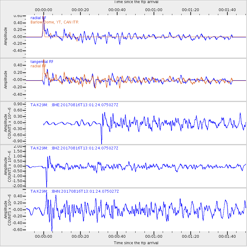
K29M Barlow Dome, YT, CAN - Earthquake Result Viewer
*The percent match for this event was below the threshold and hence no stack was calculated.
| Earthquake location: |
Northwest Of Ryukyu Islands |
| Earthquake latitude/longitude: |
28.6/127.9 |
| Earthquake time(UTC): |
2017/08/16 (228) 12:51:25 GMT |
| Earthquake Depth: |
197 km |
| Earthquake Magnitude: |
5.7 Mww |
| Earthquake Catalog/Contributor: |
NEIC PDE/us |
|
| Network: |
TA USArray Transportable Network (new EarthScope stations) |
| Station: |
K29M Barlow Dome, YT, CAN |
| Lat/Lon: |
63.84 N/137.52 W |
| Elevation: |
1367 m |
|
| Distance: |
66.6 deg |
| Az: |
28.769 deg |
| Baz: |
287.365 deg |
| Ray Param: |
$rayparam |
*The percent match for this event was below the threshold and hence was not used in the summary stack. |
|
| Radial Match: |
68.4892 % |
| Radial Bump: |
400 |
| Transverse Match: |
71.076866 % |
| Transverse Bump: |
400 |
| SOD ConfigId: |
13570011 |
| Insert Time: |
2019-04-28 14:58:42.810 +0000 |
| GWidth: |
2.5 |
| Max Bumps: |
400 |
| Tol: |
0.001 |
|
Signal To Noise
| Channel | StoN | STA | LTA |
| TA:K29M: :BHZ:20170816T13:01:24.075027Z | 9.343593 | 6.447046E-7 | 6.899965E-8 |
| TA:K29M: :BHN:20170816T13:01:24.075027Z | 3.2304332 | 2.6661436E-7 | 8.2532075E-8 |
| TA:K29M: :BHE:20170816T13:01:24.075027Z | 5.48964 | 3.1121172E-7 | 5.669073E-8 |
| Arrivals |
| Ps | |
| PpPs | |
| PsPs/PpSs | |


