You are here: Home > Network List > CU - Caribbean Network (USGS) Stations List
> Station MTDJ Mount Denham, Jamaica > Earthquake Result Viewer
MTDJ Mount Denham, Jamaica - Earthquake Result Viewer
| Earthquake location: |
Kamchatka Peninsula, Russia |
| Earthquake latitude/longitude: |
54.0/158.5 |
| Earthquake time(UTC): |
2016/01/30 (030) 03:25:10 GMT |
| Earthquake Depth: |
161 km |
| Earthquake Magnitude: |
7.2 MWW, 7.0 MI, 7.2 MWB |
| Earthquake Catalog/Contributor: |
NEIC PDE/NEIC COMCAT |
|
| Network: |
CU Caribbean Network (USGS) |
| Station: |
MTDJ Mount Denham, Jamaica |
| Lat/Lon: |
18.23 N/77.53 W |
| Elevation: |
925 m |
|
| Distance: |
93.6 deg |
| Az: |
52.174 deg |
| Baz: |
330.623 deg |
| Ray Param: |
0.041133594 |
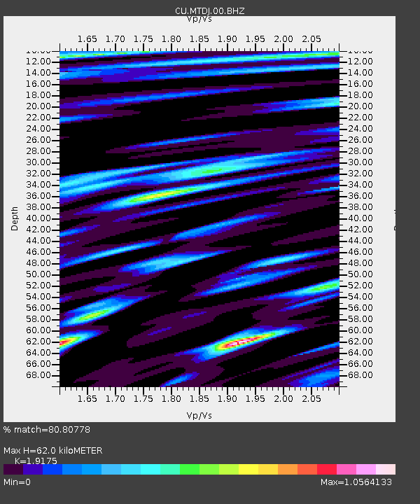
| Estimated Moho Depth: |
62.0 km |
| Estimated Crust Vp/Vs: |
1.92 |
| Assumed Crust Vp: |
4.662 km/s |
| Estimated Crust Vs: |
2.432 km/s |
| Estimated Crust Poisson's Ratio: |
0.31 |
|
| Radial Match: |
80.80778 % |
| Radial Bump: |
400 |
| Transverse Match: |
77.80342 % |
| Transverse Bump: |
400 |
| SOD ConfigId: |
1427151 |
| Insert Time: |
2016-02-13 04:05:20.876 +0000 |
| GWidth: |
2.5 |
| Max Bumps: |
400 |
| Tol: |
0.001 |
|

Signal To Noise
| Channel | StoN | STA | LTA |
| CU:MTDJ:00:BHZ:20160130T03:37:36.823992Z | 5.9793224 | 6.0361913E-6 | 1.0095109E-6 |
| CU:MTDJ:00:BH1:20160130T03:37:36.823992Z | 1.849416 | 1.8149084E-6 | 9.813414E-7 |
| CU:MTDJ:00:BH2:20160130T03:37:36.823992Z | 0.97089505 | 1.0710061E-6 | 1.1031121E-6 |
| Arrivals |
| Ps | 12 SECOND |
| PpPs | 38 SECOND |
| PsPs/PpSs | 51 SECOND |


