You are here: Home > Network List > TA - USArray Transportable Network (new EarthScope stations) Stations List
> Station O18K Koktuh Hills, AK, USA > Earthquake Result Viewer
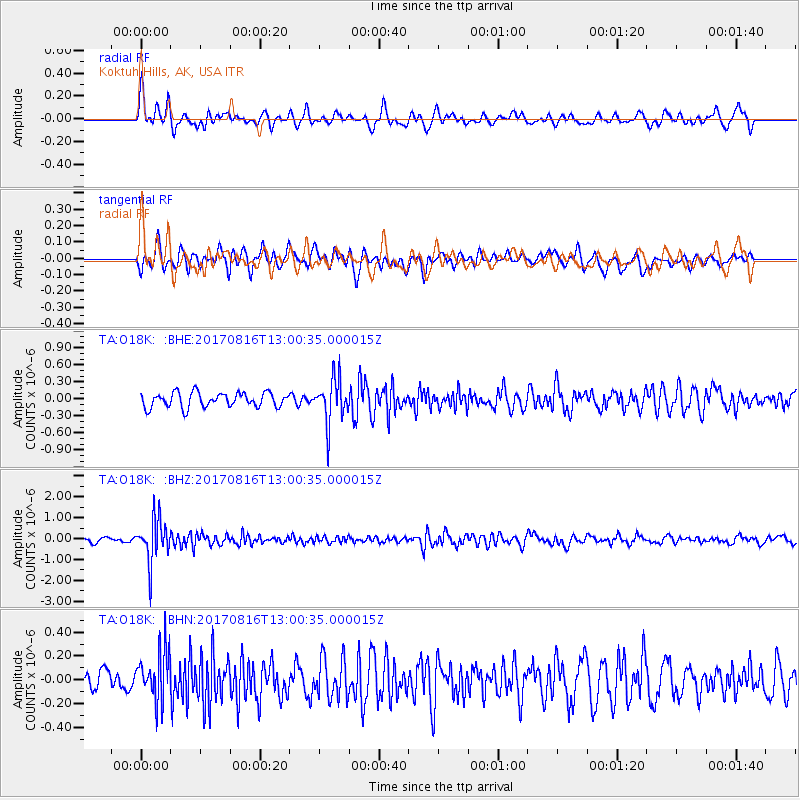
O18K Koktuh Hills, AK, USA - Earthquake Result Viewer
*The percent match for this event was below the threshold and hence no stack was calculated.
| Earthquake location: |
Northwest Of Ryukyu Islands |
| Earthquake latitude/longitude: |
28.6/127.9 |
| Earthquake time(UTC): |
2017/08/16 (228) 12:51:25 GMT |
| Earthquake Depth: |
197 km |
| Earthquake Magnitude: |
5.7 Mww |
| Earthquake Catalog/Contributor: |
NEIC PDE/us |
|
| Network: |
TA USArray Transportable Network (new EarthScope stations) |
| Station: |
O18K Koktuh Hills, AK, USA |
| Lat/Lon: |
59.85 N/155.21 W |
| Elevation: |
544 m |
|
| Distance: |
59.2 deg |
| Az: |
34.92 deg |
| Baz: |
274.565 deg |
| Ray Param: |
$rayparam |
*The percent match for this event was below the threshold and hence was not used in the summary stack. |
|
| Radial Match: |
64.57142 % |
| Radial Bump: |
400 |
| Transverse Match: |
71.84254 % |
| Transverse Bump: |
400 |
| SOD ConfigId: |
13570011 |
| Insert Time: |
2019-04-28 14:59:16.918 +0000 |
| GWidth: |
2.5 |
| Max Bumps: |
400 |
| Tol: |
0.001 |
|
Signal To Noise
| Channel | StoN | STA | LTA |
| TA:O18K: :BHZ:20170816T13:00:35.000015Z | 10.864671 | 1.0430088E-6 | 9.600003E-8 |
| TA:O18K: :BHN:20170816T13:00:35.000015Z | 3.1736314 | 2.1591033E-7 | 6.803258E-8 |
| TA:O18K: :BHE:20170816T13:00:35.000015Z | 3.0398028 | 3.907703E-7 | 1.285512E-7 |
| Arrivals |
| Ps | |
| PpPs | |
| PsPs/PpSs | |


