You are here: Home > Network List > TA - USArray Transportable Network (new EarthScope stations) Stations List
> Station R33M Jennings River, BC, CAN > Earthquake Result Viewer
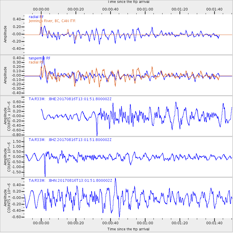
R33M Jennings River, BC, CAN - Earthquake Result Viewer
*The percent match for this event was below the threshold and hence no stack was calculated.
| Earthquake location: |
Northwest Of Ryukyu Islands |
| Earthquake latitude/longitude: |
28.6/127.9 |
| Earthquake time(UTC): |
2017/08/16 (228) 12:51:25 GMT |
| Earthquake Depth: |
197 km |
| Earthquake Magnitude: |
5.7 Mww |
| Earthquake Catalog/Contributor: |
NEIC PDE/us |
|
| Network: |
TA USArray Transportable Network (new EarthScope stations) |
| Station: |
R33M Jennings River, BC, CAN |
| Lat/Lon: |
59.39 N/130.97 W |
| Elevation: |
1437 m |
|
| Distance: |
71.1 deg |
| Az: |
32.041 deg |
| Baz: |
294.307 deg |
| Ray Param: |
$rayparam |
*The percent match for this event was below the threshold and hence was not used in the summary stack. |
|
| Radial Match: |
71.99124 % |
| Radial Bump: |
400 |
| Transverse Match: |
72.13918 % |
| Transverse Bump: |
400 |
| SOD ConfigId: |
13570011 |
| Insert Time: |
2019-04-28 14:59:38.003 +0000 |
| GWidth: |
2.5 |
| Max Bumps: |
400 |
| Tol: |
0.001 |
|
Signal To Noise
| Channel | StoN | STA | LTA |
| TA:R33M: :BHZ:20170816T13:01:51.800002Z | 4.701671 | 5.318662E-7 | 1.13122795E-7 |
| TA:R33M: :BHN:20170816T13:01:51.800002Z | 1.1977583 | 1.8861344E-7 | 1.5747203E-7 |
| TA:R33M: :BHE:20170816T13:01:51.800002Z | 2.6952782 | 2.5905416E-7 | 9.611407E-8 |
| Arrivals |
| Ps | |
| PpPs | |
| PsPs/PpSs | |


