You are here: Home > Network List > ET - CERI Southern Appalachian seismic Network Stations List
> Station SWET Sewanee,TN > Earthquake Result Viewer
SWET Sewanee,TN - Earthquake Result Viewer
| Earthquake location: |
Kamchatka Peninsula, Russia |
| Earthquake latitude/longitude: |
54.0/158.5 |
| Earthquake time(UTC): |
2016/01/30 (030) 03:25:10 GMT |
| Earthquake Depth: |
161 km |
| Earthquake Magnitude: |
7.2 MWW, 7.0 MI, 7.2 MWB |
| Earthquake Catalog/Contributor: |
NEIC PDE/NEIC COMCAT |
|
| Network: |
ET CERI Southern Appalachian seismic Network |
| Station: |
SWET Sewanee,TN |
| Lat/Lon: |
35.22 N/85.93 W |
| Elevation: |
581 m |
|
| Distance: |
75.2 deg |
| Az: |
49.808 deg |
| Baz: |
326.586 deg |
| Ray Param: |
0.0513936 |
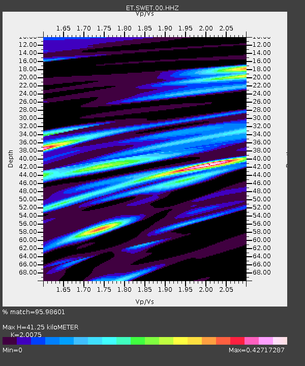
| Estimated Moho Depth: |
41.25 km |
| Estimated Crust Vp/Vs: |
2.01 |
| Assumed Crust Vp: |
6.35 km/s |
| Estimated Crust Vs: |
3.163 km/s |
| Estimated Crust Poisson's Ratio: |
0.33 |
|
| Radial Match: |
95.98601 % |
| Radial Bump: |
360 |
| Transverse Match: |
85.92446 % |
| Transverse Bump: |
400 |
| SOD ConfigId: |
1427151 |
| Insert Time: |
2016-02-13 04:05:52.014 +0000 |
| GWidth: |
2.5 |
| Max Bumps: |
400 |
| Tol: |
0.001 |
|

Signal To Noise
| Channel | StoN | STA | LTA |
| ET:SWET:00:HHZ:20160130T03:36:04.44002Z | 26.932423 | 1.6431442E-5 | 6.100989E-7 |
| ET:SWET:00:HHN:20160130T03:36:04.44002Z | 24.373621 | 5.679732E-6 | 2.3302785E-7 |
| ET:SWET:00:HHE:20160130T03:36:04.44002Z | 8.246697 | 3.4538461E-6 | 4.1881566E-7 |
| Arrivals |
| Ps | 6.7 SECOND |
| PpPs | 19 SECOND |
| PsPs/PpSs | 26 SECOND |


