You are here: Home > Network List > UW - Pacific Northwest Regional Seismic Network Stations List
> Station FISH Seaside, OR, USA > Earthquake Result Viewer
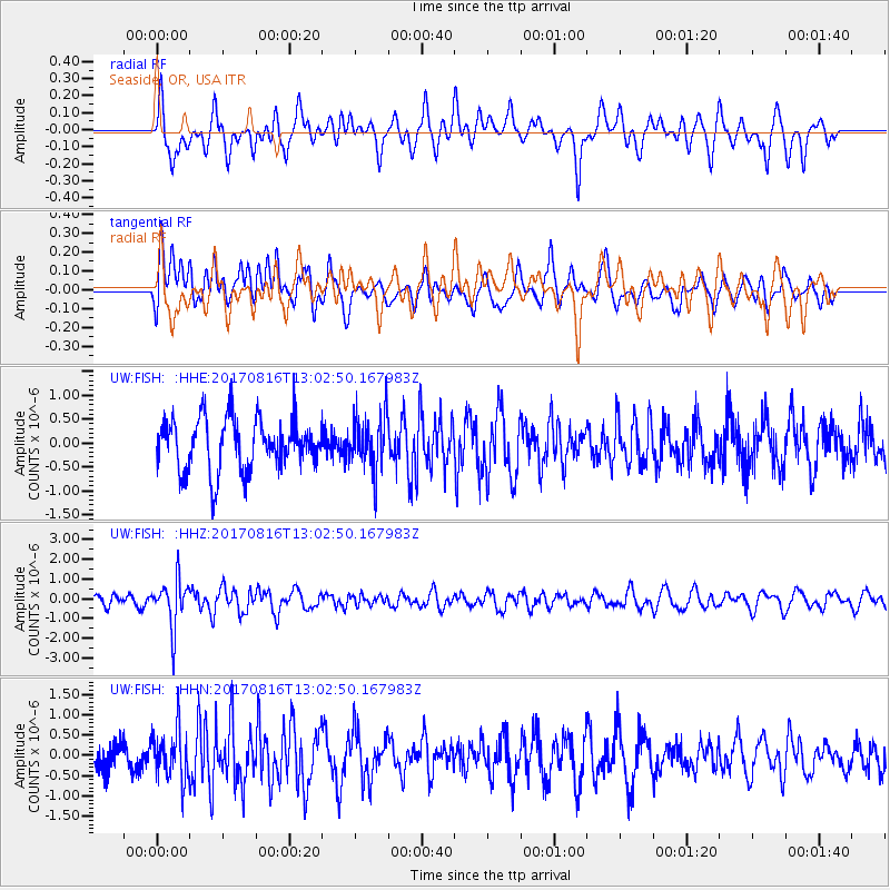
FISH Seaside, OR, USA - Earthquake Result Viewer
*The percent match for this event was below the threshold and hence no stack was calculated.
| Earthquake location: |
Northwest Of Ryukyu Islands |
| Earthquake latitude/longitude: |
28.6/127.9 |
| Earthquake time(UTC): |
2017/08/16 (228) 12:51:25 GMT |
| Earthquake Depth: |
197 km |
| Earthquake Magnitude: |
5.7 Mww |
| Earthquake Catalog/Contributor: |
NEIC PDE/us |
|
| Network: |
UW Pacific Northwest Regional Seismic Network |
| Station: |
FISH Seaside, OR, USA |
| Lat/Lon: |
45.93 N/123.56 W |
| Elevation: |
325 m |
|
| Distance: |
81.6 deg |
| Az: |
41.994 deg |
| Baz: |
302.59 deg |
| Ray Param: |
$rayparam |
*The percent match for this event was below the threshold and hence was not used in the summary stack. |
|
| Radial Match: |
54.812523 % |
| Radial Bump: |
400 |
| Transverse Match: |
52.29651 % |
| Transverse Bump: |
400 |
| SOD ConfigId: |
13570011 |
| Insert Time: |
2019-04-28 15:00:13.790 +0000 |
| GWidth: |
2.5 |
| Max Bumps: |
400 |
| Tol: |
0.001 |
|
Signal To Noise
| Channel | StoN | STA | LTA |
| UW:FISH: :HHZ:20170816T13:02:50.167983Z | 2.8747199 | 1.1911562E-6 | 4.1435558E-7 |
| UW:FISH: :HHN:20170816T13:02:50.167983Z | 1.5830698 | 6.099739E-7 | 3.8531078E-7 |
| UW:FISH: :HHE:20170816T13:02:50.167983Z | 1.0602202 | 5.740535E-7 | 5.4144743E-7 |
| Arrivals |
| Ps | |
| PpPs | |
| PsPs/PpSs | |


