You are here: Home > Network List > GS - US Geological Survey Networks Stations List
> Station DEC06 Boomer, Decatur, IL, USA > Earthquake Result Viewer
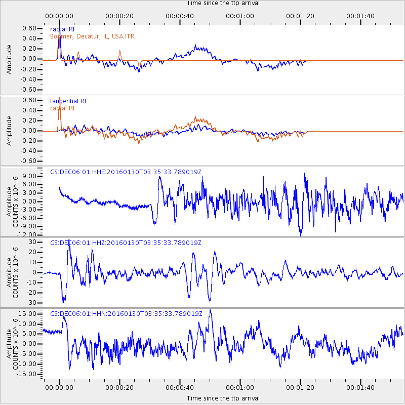
DEC06 Boomer, Decatur, IL, USA - Earthquake Result Viewer
*The percent match for this event was below the threshold and hence no stack was calculated.
| Earthquake location: |
Kamchatka Peninsula, Russia |
| Earthquake latitude/longitude: |
54.0/158.5 |
| Earthquake time(UTC): |
2016/01/30 (030) 03:25:10 GMT |
| Earthquake Depth: |
161 km |
| Earthquake Magnitude: |
7.2 MWW, 7.0 MI, 7.2 MWB |
| Earthquake Catalog/Contributor: |
NEIC PDE/NEIC COMCAT |
|
| Network: |
GS US Geological Survey Networks |
| Station: |
DEC06 Boomer, Decatur, IL, USA |
| Lat/Lon: |
39.90 N/88.95 W |
| Elevation: |
215 m |
|
| Distance: |
70.0 deg |
| Az: |
49.111 deg |
| Baz: |
324.547 deg |
| Ray Param: |
$rayparam |
*The percent match for this event was below the threshold and hence was not used in the summary stack. |
|
| Radial Match: |
54.283474 % |
| Radial Bump: |
400 |
| Transverse Match: |
54.41792 % |
| Transverse Bump: |
400 |
| SOD ConfigId: |
1427151 |
| Insert Time: |
2016-02-13 04:07:08.356 +0000 |
| GWidth: |
2.5 |
| Max Bumps: |
400 |
| Tol: |
0.001 |
|
Signal To Noise
| Channel | StoN | STA | LTA |
| GS:DEC06:01:HHZ:20160130T03:35:33.789019Z | 28.085888 | 1.7233902E-5 | 6.136143E-7 |
| GS:DEC06:01:HHN:20160130T03:35:33.789019Z | 1.8060336 | 9.637709E-6 | 5.336395E-6 |
| GS:DEC06:01:HHE:20160130T03:35:33.789019Z | 3.7746367 | 5.2796863E-6 | 1.3987271E-6 |
| Arrivals |
| Ps | |
| PpPs | |
| PsPs/PpSs | |


