You are here: Home > Network List > TA - USArray Transportable Network (new EarthScope stations) Stations List
> Station MDND Maddock, ND, USA > Earthquake Result Viewer
MDND Maddock, ND, USA - Earthquake Result Viewer
| Earthquake location: |
Off Coast Of Ecuador |
| Earthquake latitude/longitude: |
1.4/-85.2 |
| Earthquake time(UTC): |
2009/05/10 (130) 01:16:06 GMT |
| Earthquake Depth: |
6.0 km |
| Earthquake Magnitude: |
5.5 MB, 5.7 MS, 6.1 MW, 6.1 MW |
| Earthquake Catalog/Contributor: |
WHDF/NEIC |
|
| Network: |
TA USArray Transportable Network (new EarthScope stations) |
| Station: |
MDND Maddock, ND, USA |
| Lat/Lon: |
47.85 N/99.60 W |
| Elevation: |
479 m |
|
| Distance: |
47.9 deg |
| Az: |
346.929 deg |
| Baz: |
160.387 deg |
| Ray Param: |
0.069686316 |
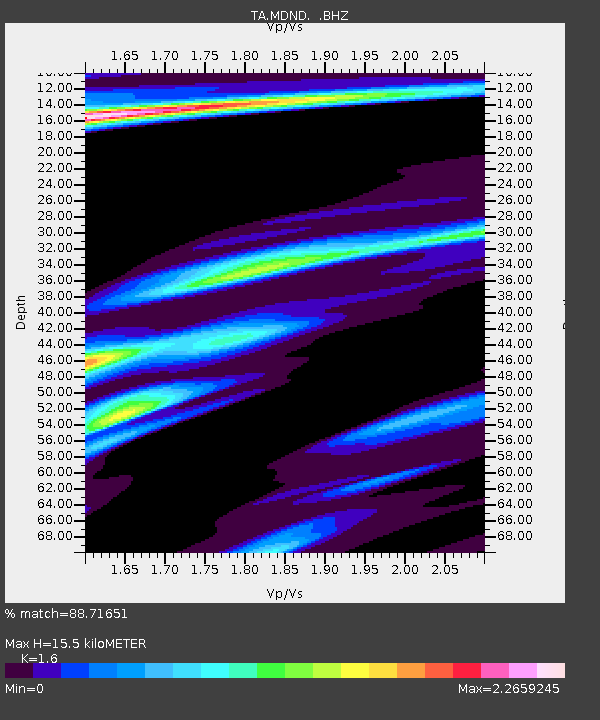
| Estimated Moho Depth: |
15.5 km |
| Estimated Crust Vp/Vs: |
1.60 |
| Assumed Crust Vp: |
6.53 km/s |
| Estimated Crust Vs: |
4.082 km/s |
| Estimated Crust Poisson's Ratio: |
0.18 |
|
| Radial Match: |
88.71651 % |
| Radial Bump: |
340 |
| Transverse Match: |
67.031 % |
| Transverse Bump: |
375 |
| SOD ConfigId: |
2760 |
| Insert Time: |
2010-03-06 02:57:06.992 +0000 |
| GWidth: |
2.5 |
| Max Bumps: |
400 |
| Tol: |
0.001 |
|
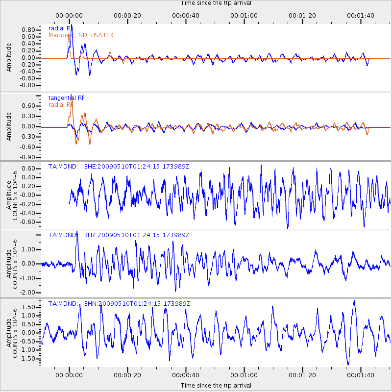
Signal To Noise
| Channel | StoN | STA | LTA |
| TA:MDND: :BHZ:20090510T01:24:15.173989Z | 8.444433 | 7.953836E-7 | 9.4190284E-8 |
| TA:MDND: :BHN:20090510T01:24:15.173989Z | 2.8209307 | 6.195617E-7 | 2.1963027E-7 |
| TA:MDND: :BHE:20090510T01:24:15.173989Z | 0.9975319 | 2.1859168E-7 | 2.1913253E-7 |
| Arrivals |
| Ps | 1.5 SECOND |
| PpPs | 5.8 SECOND |
| PsPs/PpSs | 7.3 SECOND |


