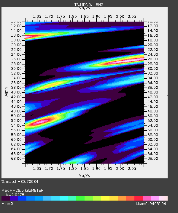
MDND Maddock, ND, USA - Earthquake Result Viewer
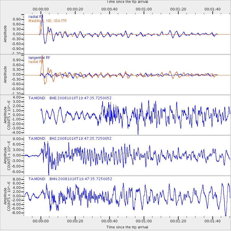
Earthquake location: Near Coast Of Chiapas, Mexico
Earthquake latitude/longitude: 14.4/-92.4
Earthquake time(UTC): 2008/10/16 (290) 19:41:25 GMT
Earthquake Depth: 24 km
Earthquake Magnitude: 6.1 MB, 6.6 MS, 6.7 MW, 6.6 MW
Earthquake Catalog/Contributor: WHDF/NEIC
Network: TA USArray Transportable Network (new EarthScope stations)
Station: MDND Maddock, ND, USA
Lat/Lon: 47.85 N/99.60 W
Elevation: 479 m
Distance: 33.9 deg
Az: 351.239 deg
Baz: 167.344 deg
Ray Param: 0.077980116
Estimated Moho Depth: 26.5 km
Estimated Crust Vp/Vs: 2.03
Assumed Crust Vp: 6.53 km/s
Estimated Crust Vs: 3.221 km/s
Estimated Crust Poisson's Ratio: 0.34
Radial Match: 83.70984 %
Radial Bump: 358
Transverse Match: 61.471416 %
Transverse Bump: 400
SOD ConfigId: 2556
Insert Time: 2010-03-06 02:57:10.546 +0000
GWidth: 2.5
Max Bumps: 400
Tol: 0.001

Signal To Noise

ChannelStoNSTALTA
TA:MDND: :BHZ:20081016T19:47:35.725005Z17.0734924.1604317E-62.4367785E-7
TA:MDND: :BHN:20081016T19:47:35.725005Z1.68105222.1577366E-61.2835632E-6
TA:MDND: :BHE:20081016T19:47:35.725005Z0.92077218.234348E-78.9428727E-7
Arrivals
Ps4.5 SECOND
PpPs11 SECOND
PsPs/PpSs16 SECOND