You are here: Home > Network List > TA - USArray Transportable Network (new EarthScope stations) Stations List
> Station MDND Maddock, ND, USA > Earthquake Result Viewer
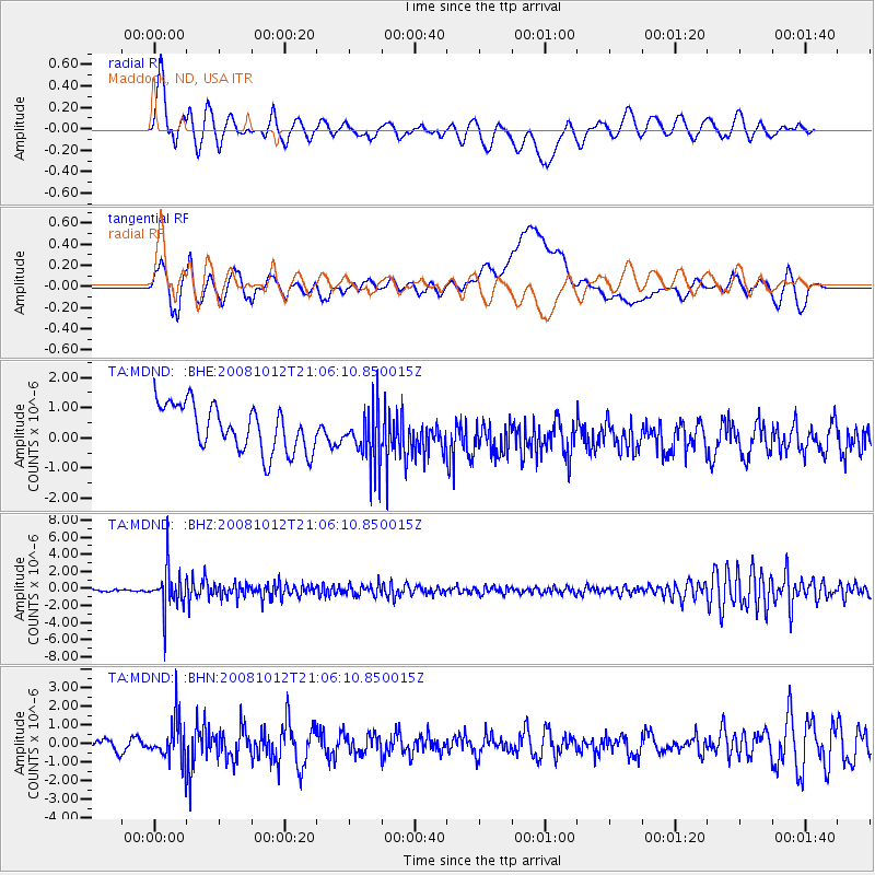
MDND Maddock, ND, USA - Earthquake Result Viewer
*The percent match for this event was below the threshold and hence no stack was calculated.
| Earthquake location: |
Southern Bolivia |
| Earthquake latitude/longitude: |
-20.1/-65.0 |
| Earthquake time(UTC): |
2008/10/12 (286) 20:55:41 GMT |
| Earthquake Depth: |
353 km |
| Earthquake Magnitude: |
6.0 MB, 6.2 MW, 6.2 MW |
| Earthquake Catalog/Contributor: |
WHDF/NEIC |
|
| Network: |
TA USArray Transportable Network (new EarthScope stations) |
| Station: |
MDND Maddock, ND, USA |
| Lat/Lon: |
47.85 N/99.60 W |
| Elevation: |
479 m |
|
| Distance: |
74.5 deg |
| Az: |
336.589 deg |
| Baz: |
146.337 deg |
| Ray Param: |
$rayparam |
*The percent match for this event was below the threshold and hence was not used in the summary stack. |
|
| Radial Match: |
68.64544 % |
| Radial Bump: |
400 |
| Transverse Match: |
59.82515 % |
| Transverse Bump: |
400 |
| SOD ConfigId: |
2556 |
| Insert Time: |
2010-03-06 02:57:48.570 +0000 |
| GWidth: |
2.5 |
| Max Bumps: |
400 |
| Tol: |
0.001 |
|
Signal To Noise
| Channel | StoN | STA | LTA |
| TA:MDND: :BHZ:20081012T21:06:10.850015Z | 9.689039 | 2.4346425E-6 | 2.51278E-7 |
| TA:MDND: :BHN:20081012T21:06:10.850015Z | 1.5451666 | 1.1228215E-6 | 7.2666694E-7 |
| TA:MDND: :BHE:20081012T21:06:10.850015Z | 1.2199775 | 9.3082843E-7 | 7.629882E-7 |
| Arrivals |
| Ps | |
| PpPs | |
| PsPs/PpSs | |


