You are here: Home > Network List > GS - US Geological Survey Networks Stations List
> Station KAN14 Livengood Farm - OK, Manchester, OK, USA > Earthquake Result Viewer
KAN14 Livengood Farm - OK, Manchester, OK, USA - Earthquake Result Viewer
| Earthquake location: |
Kamchatka Peninsula, Russia |
| Earthquake latitude/longitude: |
54.0/158.5 |
| Earthquake time(UTC): |
2016/01/30 (030) 03:25:10 GMT |
| Earthquake Depth: |
161 km |
| Earthquake Magnitude: |
7.2 MWW, 7.0 MI, 7.2 MWB |
| Earthquake Catalog/Contributor: |
NEIC PDE/NEIC COMCAT |
|
| Network: |
GS US Geological Survey Networks |
| Station: |
KAN14 Livengood Farm - OK, Manchester, OK, USA |
| Lat/Lon: |
36.96 N/97.96 W |
| Elevation: |
363 m |
|
| Distance: |
68.1 deg |
| Az: |
57.058 deg |
| Baz: |
321.799 deg |
| Ray Param: |
0.05606467 |
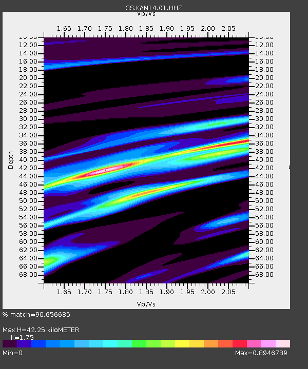
| Estimated Moho Depth: |
42.25 km |
| Estimated Crust Vp/Vs: |
1.75 |
| Assumed Crust Vp: |
6.483 km/s |
| Estimated Crust Vs: |
3.704 km/s |
| Estimated Crust Poisson's Ratio: |
0.26 |
|
| Radial Match: |
90.656685 % |
| Radial Bump: |
378 |
| Transverse Match: |
76.06708 % |
| Transverse Bump: |
400 |
| SOD ConfigId: |
1427151 |
| Insert Time: |
2016-02-13 04:08:13.482 +0000 |
| GWidth: |
2.5 |
| Max Bumps: |
400 |
| Tol: |
0.001 |
|

Signal To Noise
| Channel | StoN | STA | LTA |
| GS:KAN14:01:HHZ:20160130T03:35:22.094011Z | 22.612524 | 8.699768E-6 | 3.8473232E-7 |
| GS:KAN14:01:HHN:20160130T03:35:22.094011Z | 4.961637 | 2.926411E-6 | 5.8980754E-7 |
| GS:KAN14:01:HHE:20160130T03:35:22.094011Z | 7.9857244 | 2.4496392E-6 | 3.0675227E-7 |
| Arrivals |
| Ps | 5.1 SECOND |
| PpPs | 17 SECOND |
| PsPs/PpSs | 22 SECOND |


