You are here: Home > Network List > GS - US Geological Survey Networks Stations List
> Station OK034 N. Norfolk Rd., Cushing, Oklahoma, USA > Earthquake Result Viewer
OK034 N. Norfolk Rd., Cushing, Oklahoma, USA - Earthquake Result Viewer
| Earthquake location: |
Kamchatka Peninsula, Russia |
| Earthquake latitude/longitude: |
54.0/158.5 |
| Earthquake time(UTC): |
2016/01/30 (030) 03:25:10 GMT |
| Earthquake Depth: |
161 km |
| Earthquake Magnitude: |
7.2 MWW, 7.0 MI, 7.2 MWB |
| Earthquake Catalog/Contributor: |
NEIC PDE/NEIC COMCAT |
|
| Network: |
GS US Geological Survey Networks |
| Station: |
OK034 N. Norfolk Rd., Cushing, Oklahoma, USA |
| Lat/Lon: |
36.01 N/96.71 W |
| Elevation: |
254 m |
|
| Distance: |
69.5 deg |
| Az: |
56.827 deg |
| Baz: |
322.456 deg |
| Ray Param: |
0.055171173 |
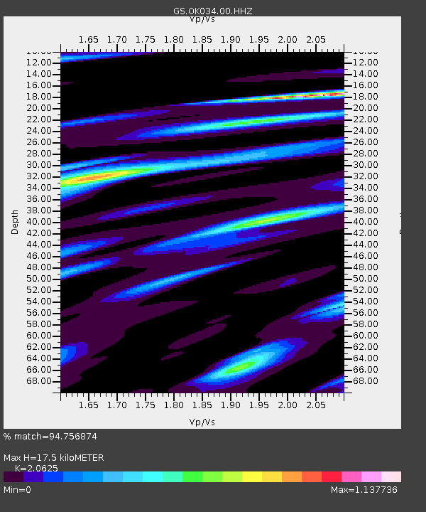
| Estimated Moho Depth: |
17.5 km |
| Estimated Crust Vp/Vs: |
2.06 |
| Assumed Crust Vp: |
6.483 km/s |
| Estimated Crust Vs: |
3.143 km/s |
| Estimated Crust Poisson's Ratio: |
0.35 |
|
| Radial Match: |
94.756874 % |
| Radial Bump: |
327 |
| Transverse Match: |
85.14093 % |
| Transverse Bump: |
400 |
| SOD ConfigId: |
1427151 |
| Insert Time: |
2016-02-13 04:08:31.456 +0000 |
| GWidth: |
2.5 |
| Max Bumps: |
400 |
| Tol: |
0.001 |
|

Signal To Noise
| Channel | StoN | STA | LTA |
| GS:OK034:00:HHZ:20160130T03:35:30.498979Z | 40.758007 | 1.3235595E-5 | 3.2473608E-7 |
| GS:OK034:00:HH1:20160130T03:35:30.498979Z | 11.181896 | 5.8844084E-6 | 5.262442E-7 |
| GS:OK034:00:HH2:20160130T03:35:30.498979Z | 10.92355 | 3.922095E-6 | 3.590495E-7 |
| Arrivals |
| Ps | 3.0 SECOND |
| PpPs | 8.0 SECOND |
| PsPs/PpSs | 11 SECOND |


