You are here: Home > Network List > TA - USArray Transportable Network (new EarthScope stations) Stations List
> Station MDND Maddock, ND, USA > Earthquake Result Viewer
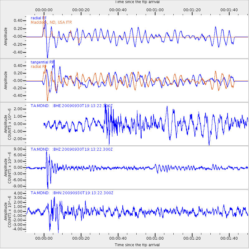
MDND Maddock, ND, USA - Earthquake Result Viewer
*The percent match for this event was below the threshold and hence no stack was calculated.
| Earthquake location: |
Peru-Bolivia Border Region |
| Earthquake latitude/longitude: |
-15.6/-69.3 |
| Earthquake time(UTC): |
2009/09/30 (273) 19:03:17 GMT |
| Earthquake Depth: |
255 km |
| Earthquake Magnitude: |
5.9 MB, 5.8 MW |
| Earthquake Catalog/Contributor: |
WHDF/NEIC |
|
| Network: |
TA USArray Transportable Network (new EarthScope stations) |
| Station: |
MDND Maddock, ND, USA |
| Lat/Lon: |
47.85 N/99.60 W |
| Elevation: |
479 m |
|
| Distance: |
68.7 deg |
| Az: |
338.598 deg |
| Baz: |
148.522 deg |
| Ray Param: |
$rayparam |
*The percent match for this event was below the threshold and hence was not used in the summary stack. |
|
| Radial Match: |
54.74789 % |
| Radial Bump: |
400 |
| Transverse Match: |
64.25048 % |
| Transverse Bump: |
400 |
| SOD ConfigId: |
2622 |
| Insert Time: |
2010-03-06 02:58:02.465 +0000 |
| GWidth: |
2.5 |
| Max Bumps: |
400 |
| Tol: |
0.001 |
|
Signal To Noise
| Channel | StoN | STA | LTA |
| TA:MDND: :BHZ:20090930T19:13:22.300Z | 18.215412 | 4.0111677E-6 | 2.2020737E-7 |
| TA:MDND: :BHN:20090930T19:13:22.300Z | 1.7664224 | 1.4363189E-6 | 8.1312317E-7 |
| TA:MDND: :BHE:20090930T19:13:22.300Z | 2.4118912 | 1.048229E-6 | 4.3460875E-7 |
| Arrivals |
| Ps | |
| PpPs | |
| PsPs/PpSs | |


