You are here: Home > Network List > TA - USArray Transportable Network (new EarthScope stations) Stations List
> Station MDND Maddock, ND, USA > Earthquake Result Viewer
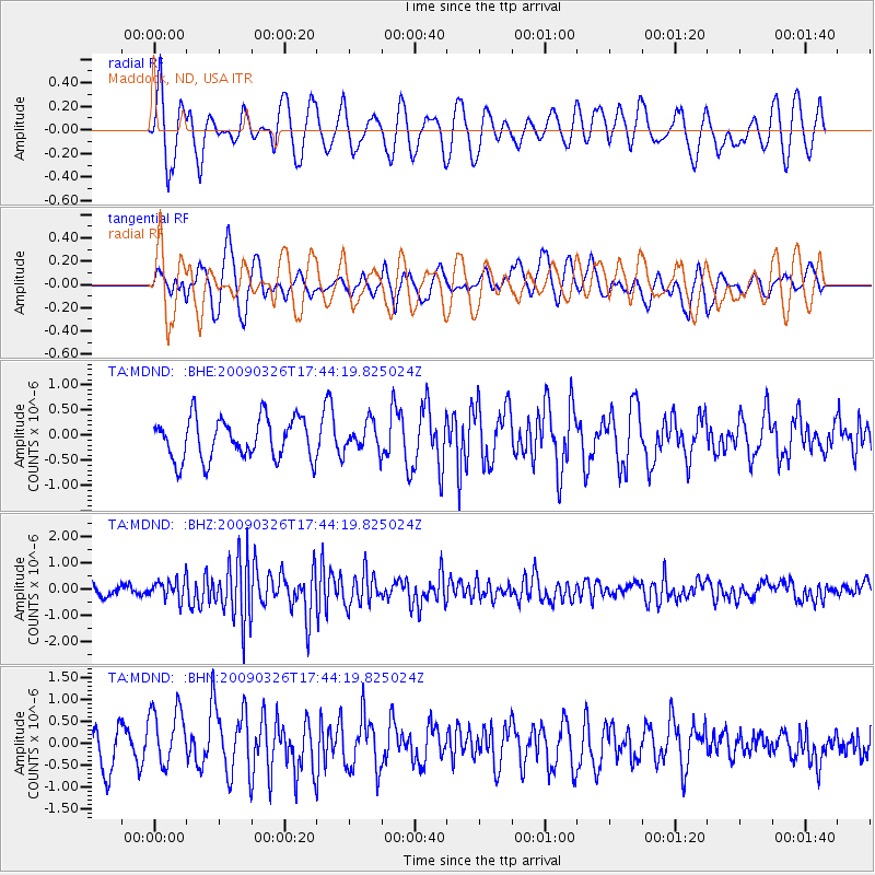
MDND Maddock, ND, USA - Earthquake Result Viewer
*The percent match for this event was below the threshold and hence no stack was calculated.
| Earthquake location: |
Near Coast Of Northern Peru |
| Earthquake latitude/longitude: |
-5.7/-81.3 |
| Earthquake time(UTC): |
2009/03/26 (085) 17:35:14 GMT |
| Earthquake Depth: |
10 km |
| Earthquake Magnitude: |
5.6 MB, 5.5 MS, 5.8 MW, 5.7 MW |
| Earthquake Catalog/Contributor: |
WHDF/NEIC |
|
| Network: |
TA USArray Transportable Network (new EarthScope stations) |
| Station: |
MDND Maddock, ND, USA |
| Lat/Lon: |
47.85 N/99.60 W |
| Elevation: |
479 m |
|
| Distance: |
55.7 deg |
| Az: |
345.197 deg |
| Baz: |
157.824 deg |
| Ray Param: |
$rayparam |
*The percent match for this event was below the threshold and hence was not used in the summary stack. |
|
| Radial Match: |
76.1554 % |
| Radial Bump: |
400 |
| Transverse Match: |
61.103504 % |
| Transverse Bump: |
400 |
| SOD ConfigId: |
2658 |
| Insert Time: |
2010-03-06 02:58:36.499 +0000 |
| GWidth: |
2.5 |
| Max Bumps: |
400 |
| Tol: |
0.001 |
|
Signal To Noise
| Channel | StoN | STA | LTA |
| TA:MDND: :BHZ:20090326T17:44:19.825024Z | 1.9926641 | 3.8425372E-7 | 1.9283416E-7 |
| TA:MDND: :BHN:20090326T17:44:19.825024Z | 2.0924666 | 7.088884E-7 | 3.3878126E-7 |
| TA:MDND: :BHE:20090326T17:44:19.825024Z | 0.69967914 | 2.8348364E-7 | 4.0516235E-7 |
| Arrivals |
| Ps | |
| PpPs | |
| PsPs/PpSs | |


