You are here: Home > Network List > TA - USArray Transportable Network (new EarthScope stations) Stations List
> Station MDND Maddock, ND, USA > Earthquake Result Viewer
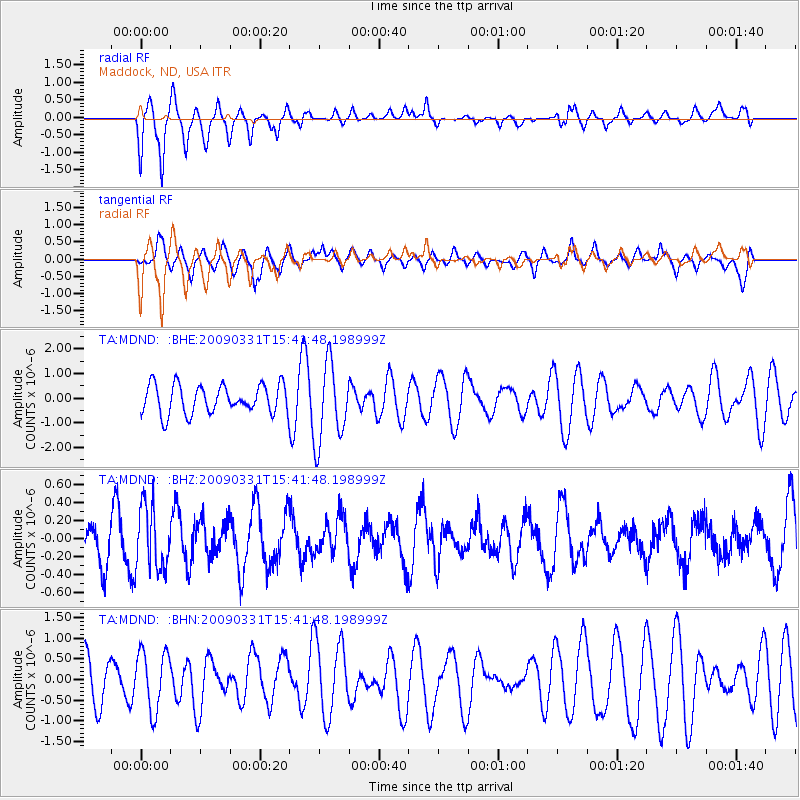
MDND Maddock, ND, USA - Earthquake Result Viewer
*The percent match for this event was below the threshold and hence no stack was calculated.
| Earthquake location: |
Mariana Islands |
| Earthquake latitude/longitude: |
18.3/145.7 |
| Earthquake time(UTC): |
2009/03/31 (090) 15:29:31 GMT |
| Earthquake Depth: |
188 km |
| Earthquake Magnitude: |
5.5 MW, 5.4 MB, 5.4 MW |
| Earthquake Catalog/Contributor: |
WHDF/NEIC |
|
| Network: |
TA USArray Transportable Network (new EarthScope stations) |
| Station: |
MDND Maddock, ND, USA |
| Lat/Lon: |
47.85 N/99.60 W |
| Elevation: |
479 m |
|
| Distance: |
92.1 deg |
| Az: |
37.766 deg |
| Baz: |
300.258 deg |
| Ray Param: |
$rayparam |
*The percent match for this event was below the threshold and hence was not used in the summary stack. |
|
| Radial Match: |
71.28252 % |
| Radial Bump: |
373 |
| Transverse Match: |
60.27486 % |
| Transverse Bump: |
366 |
| SOD ConfigId: |
2658 |
| Insert Time: |
2010-03-06 02:58:38.878 +0000 |
| GWidth: |
2.5 |
| Max Bumps: |
400 |
| Tol: |
0.001 |
|
Signal To Noise
| Channel | StoN | STA | LTA |
| TA:MDND: :BHZ:20090331T15:41:48.198999Z | 1.3540726 | 3.548662E-7 | 2.6207323E-7 |
| TA:MDND: :BHN:20090331T15:41:48.198999Z | 0.9929022 | 7.1479536E-7 | 7.199051E-7 |
| TA:MDND: :BHE:20090331T15:41:48.198999Z | 2.7547426 | 1.6120255E-6 | 5.851819E-7 |
| Arrivals |
| Ps | |
| PpPs | |
| PsPs/PpSs | |


