You are here: Home > Network List > IU - Global Seismograph Network (GSN - IRIS/USGS) Stations List
> Station PMG Port Moresby, New Guinea > Earthquake Result Viewer
PMG Port Moresby, New Guinea - Earthquake Result Viewer

| Earthquake location: |
Kamchatka Peninsula, Russia |
| Earthquake latitude/longitude: |
54.0/158.5 |
| Earthquake time(UTC): |
2016/01/30 (030) 03:25:10 GMT |
| Earthquake Depth: |
161 km |
| Earthquake Magnitude: |
7.2 MWW, 7.0 MI, 7.2 MWB |
| Earthquake Catalog/Contributor: |
NEIC PDE/NEIC COMCAT |
|
| Network: |
IU Global Seismograph Network (GSN - IRIS/USGS) |
| Station: |
PMG Port Moresby, New Guinea |
| Lat/Lon: |
9.40 S/147.16 E |
| Elevation: |
90 m |
|
| Distance: |
63.9 deg |
| Az: |
192.485 deg |
| Baz: |
7.431 deg |
| Ray Param: |
0.058807243 |
| Estimated Moho Depth: |
41.0 km |
| Estimated Crust Vp/Vs: |
1.60 |
| Assumed Crust Vp: |
6.122 km/s |
| Estimated Crust Vs: |
3.826 km/s |
| Estimated Crust Poisson's Ratio: |
0.18 |
|
| Radial Match: |
94.15444 % |
| Radial Bump: |
400 |
| Transverse Match: |
86.396996 % |
| Transverse Bump: |
400 |
| SOD ConfigId: |
1427151 |
| Insert Time: |
2016-02-13 04:10:54.046 +0000 |
| GWidth: |
2.5 |
| Max Bumps: |
400 |
| Tol: |
0.001 |
|
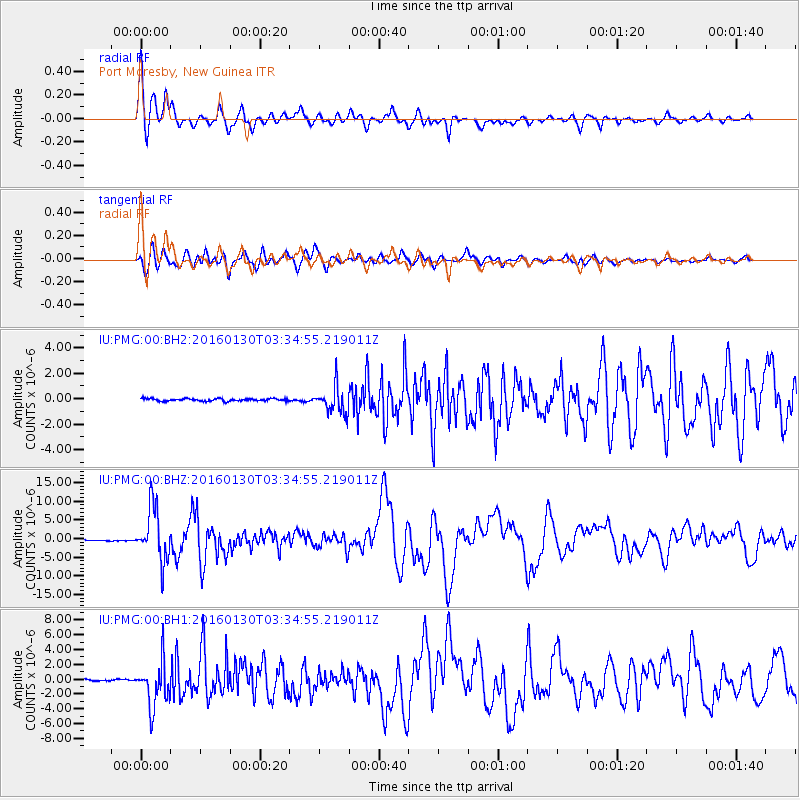
Signal To Noise
| Channel | StoN | STA | LTA |
| IU:PMG:00:BHZ:20160130T03:34:55.219011Z | 68.25213 | 7.1262943E-6 | 1.04411306E-7 |
| IU:PMG:00:BH1:20160130T03:34:55.219011Z | 24.884895 | 3.0038475E-6 | 1.2070967E-7 |
| IU:PMG:00:BH2:20160130T03:34:55.219011Z | 11.017182 | 1.0580839E-6 | 9.6039415E-8 |
| Arrivals |
| Ps | 4.2 SECOND |
| PpPs | 17 SECOND |
| PsPs/PpSs | 21 SECOND |


