You are here: Home > Network List > TA - USArray Transportable Network (new EarthScope stations) Stations List
> Station A21K Barrow, AK, USA > Earthquake Result Viewer
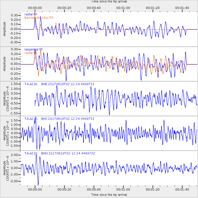
A21K Barrow, AK, USA - Earthquake Result Viewer
*The percent match for this event was below the threshold and hence no stack was calculated.
| Earthquake location: |
Fiji Islands Region |
| Earthquake latitude/longitude: |
-18.0/-178.9 |
| Earthquake time(UTC): |
2017/08/19 (231) 02:00:52 GMT |
| Earthquake Depth: |
539 km |
| Earthquake Magnitude: |
6.4 Mww |
| Earthquake Catalog/Contributor: |
NEIC PDE/us |
|
| Network: |
TA USArray Transportable Network (new EarthScope stations) |
| Station: |
A21K Barrow, AK, USA |
| Lat/Lon: |
71.32 N/156.62 W |
| Elevation: |
577 m |
|
| Distance: |
90.4 deg |
| Az: |
7.002 deg |
| Baz: |
201.11 deg |
| Ray Param: |
$rayparam |
*The percent match for this event was below the threshold and hence was not used in the summary stack. |
|
| Radial Match: |
58.12069 % |
| Radial Bump: |
400 |
| Transverse Match: |
56.33787 % |
| Transverse Bump: |
400 |
| SOD ConfigId: |
13570011 |
| Insert Time: |
2019-04-28 15:18:34.323 +0000 |
| GWidth: |
2.5 |
| Max Bumps: |
400 |
| Tol: |
0.001 |
|
Signal To Noise
| Channel | StoN | STA | LTA |
| TA:A21K: :BHZ:20170819T02:12:24.449973Z | 2.2721977 | 1.1331516E-6 | 4.9870295E-7 |
| TA:A21K: :BHN:20170819T02:12:24.449973Z | 2.1374688 | 1.2114941E-6 | 5.6678914E-7 |
| TA:A21K: :BHE:20170819T02:12:24.449973Z | 0.8445323 | 4.424041E-7 | 5.238451E-7 |
| Arrivals |
| Ps | |
| PpPs | |
| PsPs/PpSs | |


