You are here: Home > Network List > TA - USArray Transportable Network (new EarthScope stations) Stations List
> Station B22K Teshekpuk Lake, AK, USA > Earthquake Result Viewer
B22K Teshekpuk Lake, AK, USA - Earthquake Result Viewer
*The percent match for this event was below the threshold and hence no stack was calculated.
| Earthquake location: |
Fiji Islands Region |
| Earthquake latitude/longitude: |
-18.0/-178.9 |
| Earthquake time(UTC): |
2017/08/19 (231) 02:00:52 GMT |
| Earthquake Depth: |
539 km |
| Earthquake Magnitude: |
6.4 Mww |
| Earthquake Catalog/Contributor: |
NEIC PDE/us |
|
| Network: |
TA USArray Transportable Network (new EarthScope stations) |
| Station: |
B22K Teshekpuk Lake, AK, USA |
| Lat/Lon: |
70.34 N/153.42 W |
| Elevation: |
50 m |
|
| Distance: |
89.9 deg |
| Az: |
8.357 deg |
| Baz: |
204.126 deg |
| Ray Param: |
$rayparam |
*The percent match for this event was below the threshold and hence was not used in the summary stack. |
|
| Radial Match: |
62.077744 % |
| Radial Bump: |
337 |
| Transverse Match: |
62.316814 % |
| Transverse Bump: |
387 |
| SOD ConfigId: |
13570011 |
| Insert Time: |
2019-04-28 15:18:38.667 +0000 |
| GWidth: |
2.5 |
| Max Bumps: |
400 |
| Tol: |
0.001 |
|
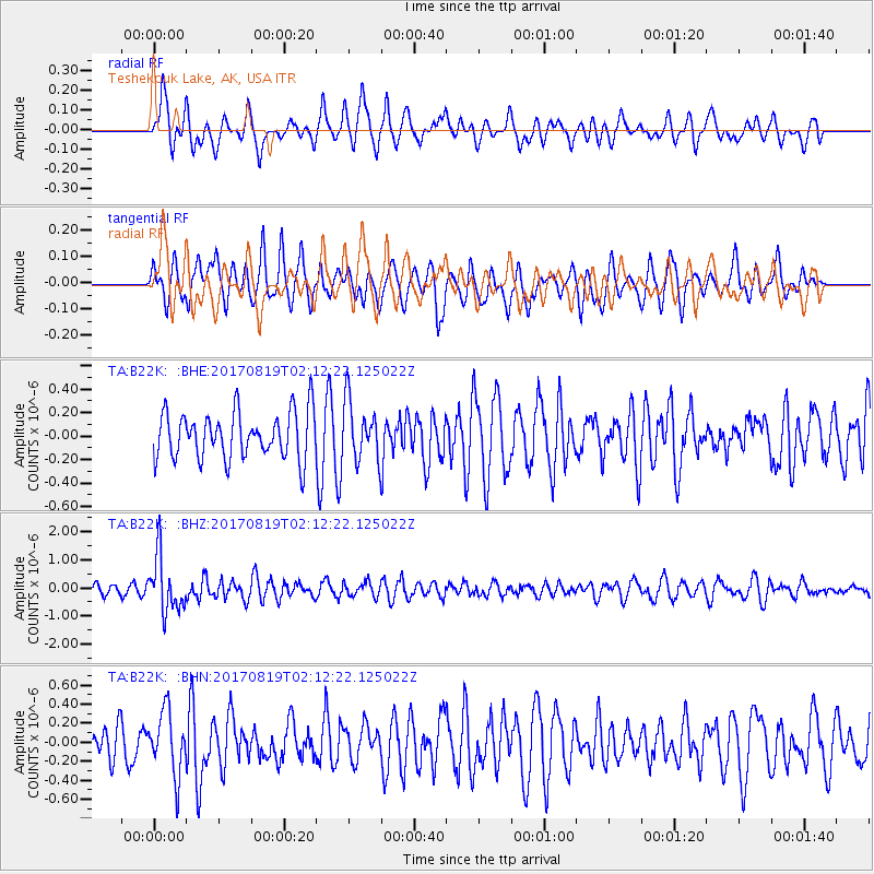
Signal To Noise
| Channel | StoN | STA | LTA |
| TA:B22K: :BHZ:20170819T02:12:22.125022Z | 4.3838825 | 9.807267E-7 | 2.237119E-7 |
| TA:B22K: :BHN:20170819T02:12:22.125022Z | 1.841841 | 3.2940642E-7 | 1.7884628E-7 |
| TA:B22K: :BHE:20170819T02:12:22.125022Z | 1.2476051 | 2.4904622E-7 | 1.9961942E-7 |
| Arrivals |
| Ps | |
| PpPs | |
| PsPs/PpSs | |


