You are here: Home > Network List > TA - USArray Transportable Network (new EarthScope stations) Stations List
> Station D25K Kavik River, AK, USA > Earthquake Result Viewer
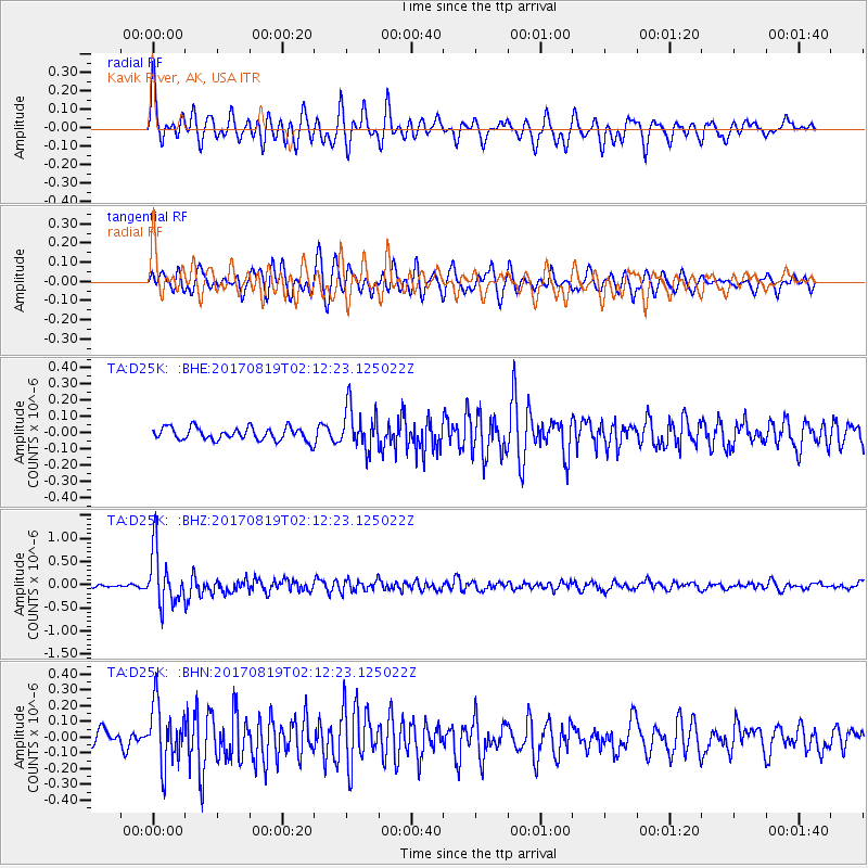
D25K Kavik River, AK, USA - Earthquake Result Viewer
*The percent match for this event was below the threshold and hence no stack was calculated.
| Earthquake location: |
Fiji Islands Region |
| Earthquake latitude/longitude: |
-18.0/-178.9 |
| Earthquake time(UTC): |
2017/08/19 (231) 02:00:52 GMT |
| Earthquake Depth: |
539 km |
| Earthquake Magnitude: |
6.4 Mww |
| Earthquake Catalog/Contributor: |
NEIC PDE/us |
|
| Network: |
TA USArray Transportable Network (new EarthScope stations) |
| Station: |
D25K Kavik River, AK, USA |
| Lat/Lon: |
69.32 N/146.38 W |
| Elevation: |
770 m |
|
| Distance: |
90.1 deg |
| Az: |
10.995 deg |
| Baz: |
210.736 deg |
| Ray Param: |
$rayparam |
*The percent match for this event was below the threshold and hence was not used in the summary stack. |
|
| Radial Match: |
75.75747 % |
| Radial Bump: |
371 |
| Transverse Match: |
74.931854 % |
| Transverse Bump: |
400 |
| SOD ConfigId: |
13570011 |
| Insert Time: |
2019-04-28 15:18:47.499 +0000 |
| GWidth: |
2.5 |
| Max Bumps: |
400 |
| Tol: |
0.001 |
|
Signal To Noise
| Channel | StoN | STA | LTA |
| TA:D25K: :BHZ:20170819T02:12:23.125022Z | 14.216781 | 5.8771263E-7 | 4.1339362E-8 |
| TA:D25K: :BHN:20170819T02:12:23.125022Z | 4.1515727 | 1.9084118E-7 | 4.5968406E-8 |
| TA:D25K: :BHE:20170819T02:12:23.125022Z | 3.2863696 | 1.2838491E-7 | 3.9065874E-8 |
| Arrivals |
| Ps | |
| PpPs | |
| PsPs/PpSs | |


